
Activity Feed › Discussion Forums › Education & Training › Help with City Of Austin, Tx Monument Datasheets
Help with City Of Austin, Tx Monument Datasheets
Posted by willie-h on March 18, 2021 at 3:18 pmI am posting in “Education and Training” because I need some of both for this issue.
I am reaching out to anyone who has worked in the Austin area. I can not find datasheets for their monuments. The GIS site is slick COA_MONUMENTS, and provides nice X,Y,Z info. i have reached out to the public works department to reach a surveyor but I am under the impression they are still working with minimal personal due to COVID since I have not received a response form anyone.
I would feel much better adjusting to them and providing a transformation to work on if I had the datasheets. Could anyone provide some insight?
mathteacher replied 3 years, 1 month ago 11 Members · 27 Replies- 27 Replies

@willie-h You might PM @flyin-solo on here or look for Kent McMillian on FB. I believe both are experienced in Austin.

Kent

No datasheets that I’m aware of. We went to the city Road and Bridge department inside Texas One Center and talked to a fella named John. They are VERY slow to respond but have hand written field notes for some of the city monuments, that I’ve used in the past.
T. Nelson – SAM, LLC
I wonder how many cities do maintain a database of their control, and have datasheets?
The City of Pittsburgh had an extensive control network, with a published map series (Series 7 @ 1:2400, comprising 154 sheets plus an index sheet) showing the traverses and stations with names. I have a set of those maps, which I have scanned. Here is one of the sheets…
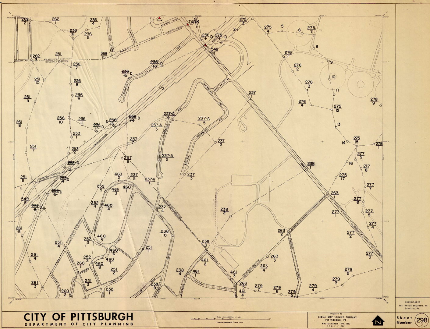
I have heard that there are 1800 traverse points (I had previously thought someone told me it was 18,000, but I think that was mistaken after looking at the sheets), all done with transit and tape. And a first order triangulation network with 100+ stations. But, they allegedly threw out the field books and computations in the 60’s, now all they have left are index cards with coordinates and descriptions. And they are not scanned or online. One has to visit the DPW office to get copies of the cards. I have heard that some are missing. I gave a presentation a few years ago about the City network (and the USACE Harbor Line System), and the local penndot office chief surveyor expressed interest in getting the cards and scanning them. But nothing has happened so far as I know.
I am not sure if there are even any surveyors working for the city anymore. Philadelphia, at the other end of the state, has (or had) a large survey division, with something like 16 survey districts in the City. I did a bluebook project for Philadelphia back in the early 90’s where we established a network of new GPS stations covering the city. Not sure if they use that network now or if they still have their own old network.
https://www.phila.gov/phils/docs/inventor/graphics/agencies/A090.htm

We actually do. And we’re trying to get it all online with the GIS.And even potentially broadcast a solution of or LDP for anyone working with and in the city limits and the LDP area.

Mr. Willie H,
Please contact me through my email: [email protected]
I have 3 contact names for the COA with emails.
I know one is still valid because I deal with him regularly. The other two I see at the TSPS Christmas Party occasionally.
They are working “out of office” due to the current pandemic.
I have used the monuments before, but never had the data sheets.

@john-hamilton I have pulled data sheets for the City Of Georgetown which is just North of Austin, that is why I started looking for them for Austin. I am pretty new to surveying so I assumed most cities kept datasheets. I could be very wrong.
The city keeps a nice GIS portal with X,Y,Z data, but nothing else. Not even a description of what is in the ground.

@bryan-newsome
Bryan- used to be a browser thing- if you used IE instead of Chrome and right-clicked on the feature it’d pull up the PDF. I’m guessing 97% of the ones I ever saw were set and sheeted by McG&McG and were either in the 96 or 99 Geoid. I’m trying right now to see if that still holds true for Microsoft Edge (or whatever it’s called), but per usual lately the site is running doggy as can be. Ok- just tried it. If you click the hyperlink for the data sheet it pulls up an empty about:blank. If you right click the hyperlink and “open in new tab/window” it links to a PDF on the COA ftp, but it too comes up blank. guessing there’s one of the usual issues with ftp security/public access that you run into here and there. i haven’t checked into/against a city monument in a long time- the great streets stuff downtown wiped out virtually everything from UT down to town lake, and otherwise i have so much established control around town that i just don’t need it.
And as for the COA survey dept/archives… been thinking somebody needs to take the reins to defend/protect it. It’s eroding at an alarming rate RIGHT NOW. I thought- for about 3 seconds- about applying for John’s job when he retired. If I didn’t have two impending college students and their associated costs, might have done it. But alas, kids gotta eat. I feel for the crew holding on, but it’s a shell of what it was even 10 years ago. And the original records are likely disappearing on the output side of whatever scanner is being used to make them digital. And the digital records are, for the most part, just being dumped into one large pile of info. Whereas previously it might take a week to find what you’re looking for you’d still eventually find it. I’m afraid that’s going to take much longer now, if things can be found at all. I don’t know if anyone currently practicing has spent as much time in that room as I have, almost feels like watching a glacier melt or something…
This is a perfect example of where the government thing should hire a private contractor to do the scanning so they can’t screw it up. And continue doing their normal day to day.

Go to the Austin survey monument page: https://data.austintexas.gov/Locations-and-Maps/Survey-Monument/77pj-hs7w
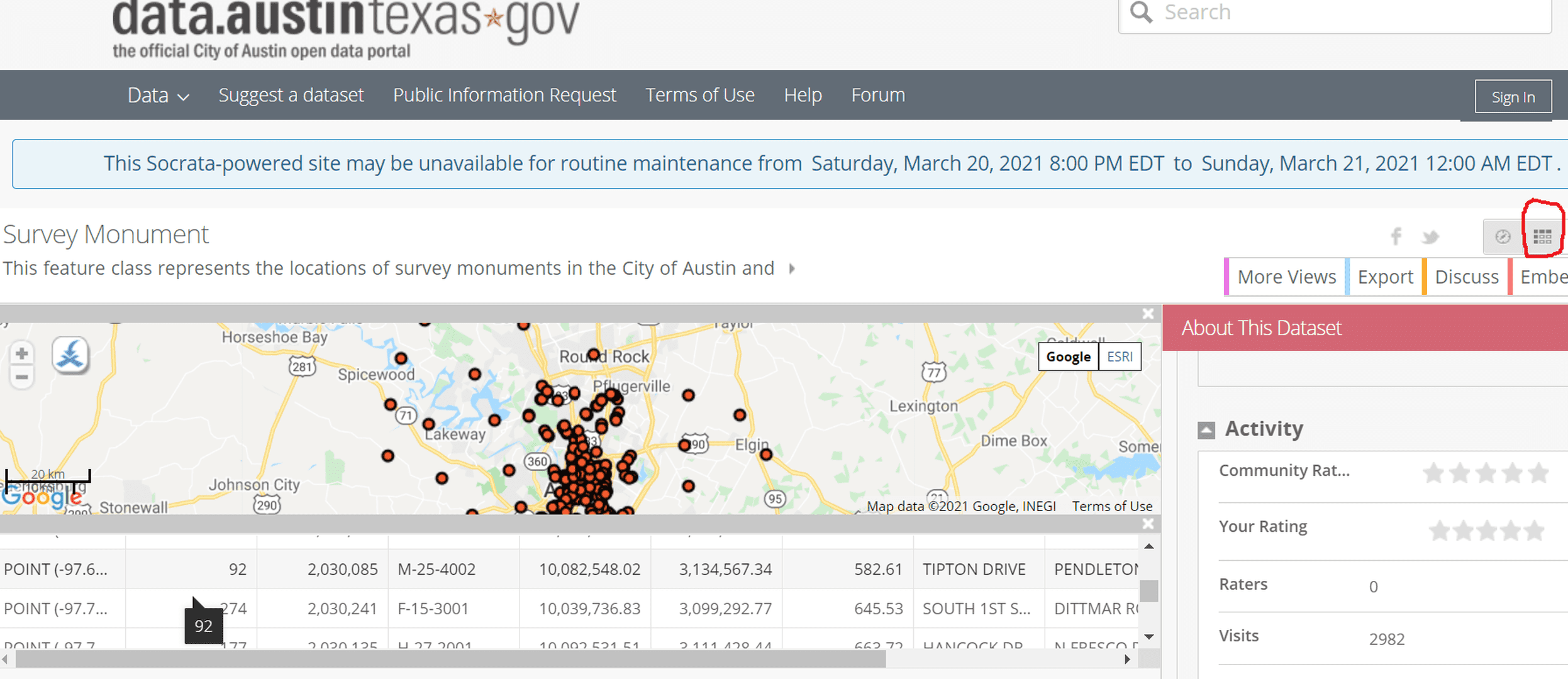
In the picture above note my crude circle in the upper right-hand side. Clicking that gives you a table view of the data. The Point contains lon/lat for the point which you can see by hovering your mouse over the word Point 92 is -97.677776… , 30.299180…
Not a data sheet, but it might be enough for you to correlate your points.
Dang!! It’s actually easier than that. Click on the box to the immediate right of the circled one. The lon/lat will come up at the bottom in a convenient format.
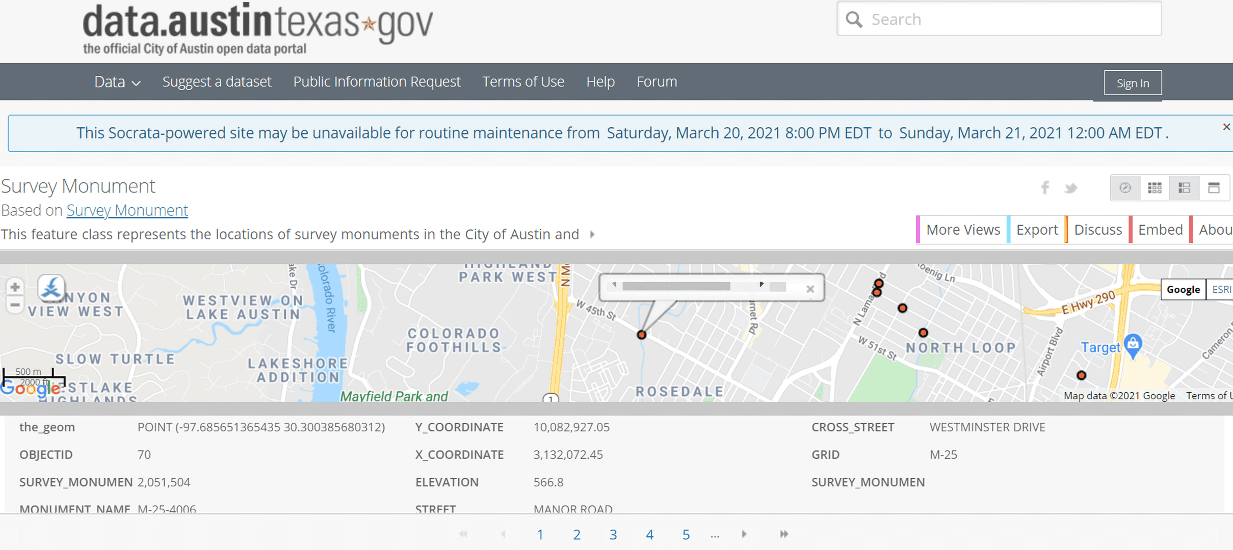
Well, double dang!!! There’s an export button just under those “table” icons. Just pick the format you want. I tried CSV for Excel and got the whole file. Lon/lat are in the first column; just expand it to see all the digits.
Sorry ’bout that. I usually do a more thorough job before I post.
@mathteacher this the site I referred to in my first post. It’s really slick and handy, but the boss was wanting to see datasheets. Thank you for your time, it is appreciated.
@bryan-newsome will do!
I’d say the boss is pretty wise. Just doing a little quick spot checking on the downloaded csv file.
Running the lon/lat for object ID’s 268, 258, and 207 through NCAT shows that the COA coordinates are 2-3 feet different from Texas state plane in both Northing and Easting. That’s sorta what one might expect.
But ol’ object ID 110 is 100 feet different from Texas state plane in Northing and the expected 2-3 feet different in Easting.
I would want to see the primary data source, too.
I got curious about the extent of errors in the downloaded coordinates from Austin, so I created an input file for NCAT by copying the three columns it needs from the download to sheet 2 in the same workbook, saving it as a CSV file. I used Notepad to fix commas, remove stray parentheses, etc., and submitted it to NCAT.
The NCAT download gave me the Texas State Plane coordinates for the lon/lat from Austin. I copied those values to the input Austin download and compared the Austin coordinates to the state plane coordinates.
They’re not going to be the same, but they shouldn’t be too far apart either. The work took a little less than an hour and showed five points with significant differences. I’ve shared those with the City of Austin “Open Data Team” who hopefully will share them with the GIS team.
The final spreadsheet is attached.
i don’t in any way want to discourage you, and i’ve traded DMs with Willie explaining as much, but i think your efforts are ultimately for naught. while the city GIS looks awfully slick, and is useful for various qualitative data, the survey data is of decidedly GIS quality- which is to say somebody(s) not in the survey department (likely because the survey department does little these days outside of redlining easement submittals) slapped some NEZs on features and stuck them on their website. it’s been years since i’ve relied on any city-listed control for anything other than convenience sake- it was all set, i believe, as part of a contract in the late 90s and is neither maintained nor replaced when destroyed, and a good number of them have been destroyed. in my opinion even having that info online at this point is a disservice to anyone looking for survey quality information, and would qualify as deceptive were there any sort of competence behind listing it.
the city is a real mess for surveyors to deal with. as stated above, the survey department is hanging on by a thread, the legal and real estate departments are staffed almost exclusively by newbies, as anyone with experience can earn 2-3 times the salary working anywhere else, and the GIS department seems to be staffed by ghosts…
i get why Willie’s boss would want that info, but I seriously doubt it’s what he (or she) is even looking for, and besides- the city doesn’t even reference their own control on anything they work with, not sure why a competent surveyor would.
I agree wholeheartedly. When a 75-year-old retired math teacher can find the number of inconsistencies that I did in a downloaded file, the situation is not good. We’ll see if those get corrected. My guess is that it won’t be any time soon if at all.
Again, Willie’s boss is smart to ask for the source data, the data sheets. From reading your post, though, they may not be much better.
Interestingly, there is information about Freedom of Information requests on the Open Data contact page. I hope that Willie doesn’t have to go that route to get what he needs.
For me, identifying the blunders was a much-needed exercise in data manipulation (I need to stay in practice) instead of a better-the-world project. But it was so easy that it begged the question: Why didn’t somebody do something similar before posting the file?
the original data sheets are what you??d expect- SPC northings, eastings, and geoid referenced elevations, along with a vicinity sketch with ties to several reference points. but I??ve never once seen a check-in or any evidence of updated info on one. I suspect that, when set, there was likely an expectation and/or desire that a robust network would be maintained and referenced, but it just never happened. And I haven??t done a ton of projects FOR the city, but I??m about 99.9% positive their own control doesn??t even register on their radar when such projects are done.


Log in to reply.