
Activity Feed › Discussion Forums › Education & Training › The Three Mile method ….
The Three Mile method ….
Posted by jitterboogie on May 23, 2021 at 2:58 amResearching a potential job I’d like to pursue, stumbled across this….it’s always fun realizing how much more I need/ want to learn about the profession. It makes all the patch work Indian Trust land grids make perfect sense, sort of.
aliquot replied 2 years, 11 months ago 8 Members · 22 Replies- 22 Replies


Funny. I found the similar version to in a presentation with the Colorado Ute land surveying process.
Again. This site always has such great content.

Then there is the one mile method.
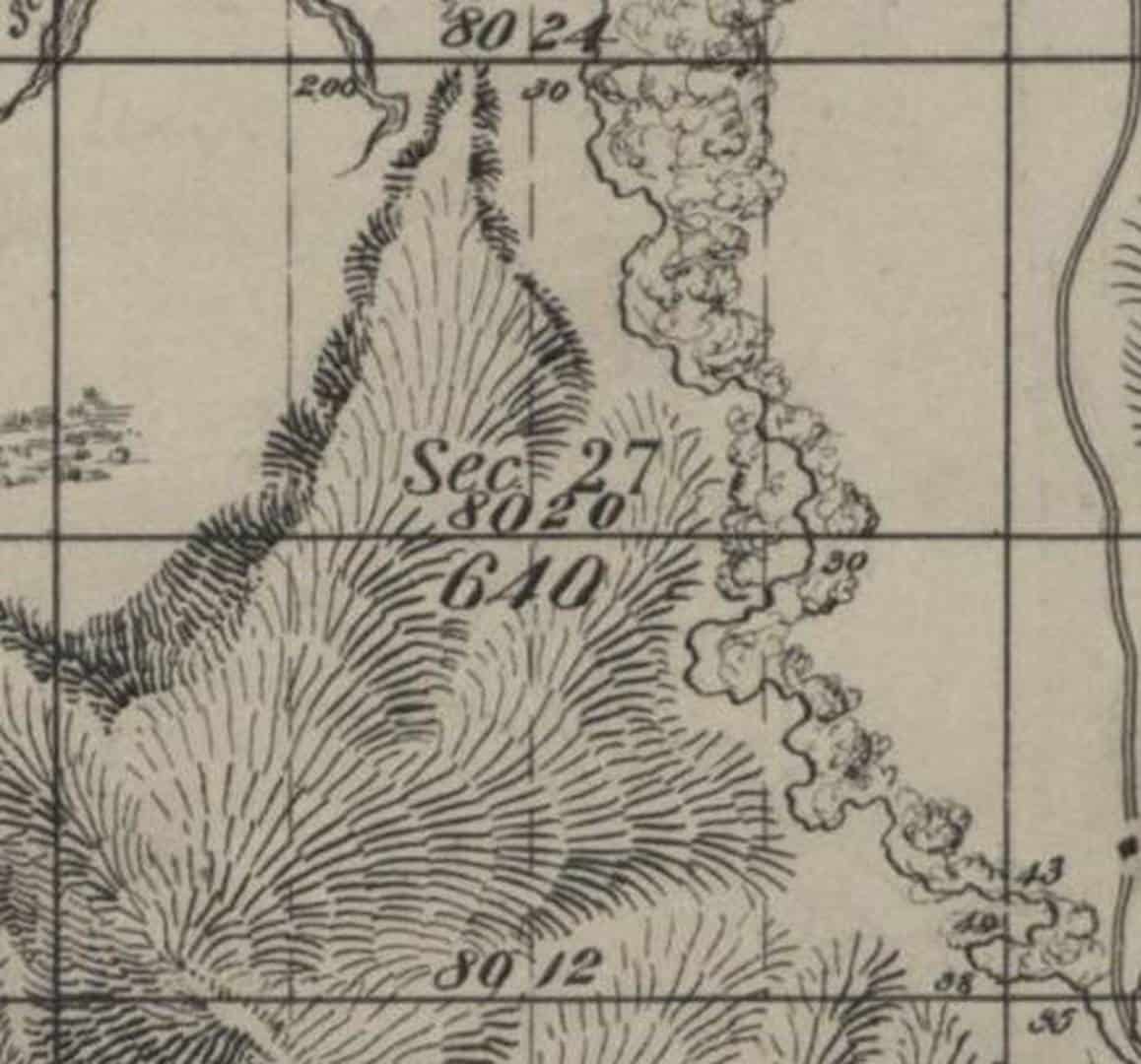
Along the north and south section lines the east and west 1/16th were set, also the same was done for the east-west centerline of the section running line between the E1/4 and the W1/4. These 1/16ths were called and scribed as 1/8 corners.
Question; given that process how should the NE, NW, SW, and SE1/16th be surveyed? Assuming there is no evidence of any of them being set prior.

Most of the townships in the eastern portion of the county where I reside were subdivided for allotments in this manner. Properly retracing the surveys can be challenging. One of the more confusing aspects is that these 40 acre allotments were almost exclusively conveyed by aliquot descriptions, as in “SW/4 of the SW/4”. This apparently gave later surveyors license to employ improper retracement technique. There are a lot more ways to retrace these incorrectly than correctly.
One must read the original notes, not just look at the plat. Especially when closing on the west line of the township. Working around these can be a PITA.

 Posted by: @paden-cash
read the original notes
truer words were never spoken…
 I hope everyone has a great day; I know I will!
Any general advise is dangerous, let the plats and the notes guide you.
One question that might be important is were the original patents for E&W 1/2’s of 1/4’s ?

I would start with searching for any long accepted local practice of record. Not much point inventing something new. I would be especially mindful of any case law on subdividing these types of sections.
Assuming an absence of any possession or methods of record, recover or restore all pertinent corners actually set. Monument the north or south sixteenths on the section line by proportion (midpoint).
The next part I would compute several ways to see which produces the least distortion. The most likely would be honor the east and west sixteenth lines, proportion the north and south sixteenths on the east and west section lines and north south center section line. Connect the dots.
It is very simple to run this several ways and I wouldn’t hesitate to try several on the computer screen. I would of course perform an additional search before setting anything.
The final step would be publish a book with a collection of these oddities.
The question I posed is the 1/4 has not been divided, all the original corners are recovered, how is the center of the 1/4 placed. The NE1/16th corner for the above Sec27 is placed where?
The question was “Question; given that process how should the NE, NW, SW, and SE1/16th be surveyed?”.
Rather than pick one I gave a procedure that honored lines surveyed and could be used to place any or all.
The NE 16th would be placed at the intersection of the borth and east 16th lines as above, unless that greatly distorted the areas.
Again that a thumnail sketch of one way to honor the lines actually run and the plat. I’d put more thought in it if it were a job on the ground.
The plat gives the answer, as with the CN1/16th being mid-point between the N1/4 and C1/4, the NE1/16th would be mid-point between the 1/8th monuments.
We are blind without the notes. From the plat it looks like the C1/4 probably was set. If it was and is now lost, you would probably set it at proportional distance between the E1/4 and and the W1/4, just like the logical and established method for the three mile method. This would protect the plat and replace it it in the most likely position.
Of course, if there is no federal interest and others before you have done something else, all that goes out the window.
Dashed lines indicate protracted lines, in this case eighths of a section. Those lines are identical to the method of placing a sixteenth line, and would not control the same as lines run on the ground. Your method may be perfectly valid, but it is not prescribed by the plat. It would be better to search regional, district or special instructions for the place an period than to assume thst is what the plat means.
Of course this is probably an unsubdivided section in private ownership. Imposing any particular method is unlikely to settle the matter with finality if the owners don’t like it.
I do enjoy these threads and you certainly made me think. Hopefully you understand my comments to be friendly argument with a touch of devils advocate..
In this case I would not set the lost C1/4 at a proportional distance between the E1/4 and the W1/4. I would set it at a proportional distance between the two 1/8th corners on the E-W centerline since they would be controlling, assuming they aren’t lost. Same with the N1/4 and the S1/4. As an aside lost corners in this area are rare.
We are saying the same thing. In the PLSS intermediate controlling corners cotrol proportions. You can never be sure that you are not skipping any without the notes. So when the proper procedure is to proportion between two points it should always be understood that a check for intermediate controlling corners is required and closest existatant corners on the specified line should be used, even if it just a line tree.
Maybe I should have said, “proportional distance on the line connecting the E&W 1/4’s”
Is the C1/4 lost, or was it never set?
Apparently this was a pretty good thing to serendipitously mention….I’ll keep posting my lack of knowledge so ya’ll can keep filling my brain ?? .
Thanks for all the posts.
The three mile method, and the one mile method make a surveyor think outside what is “normal” in the PLSS.
And I’m just stuffing the 2 lb bag with as much as I can!

If it is the Ute Meridian you are researching you are welcome to contact the Mesa County Surveyor (me) for pertinent information.
Mesa County is bordered by the Salt Lake Meridian and contains townships of the New Mexico Meridian, the 6th P.M. and the entire Ute Meridian.
Hey There,
Its is what I was reading about, mostly just to get acquainted with something I’ve never looked at yet.
I might be working around there, and if I do I know we’ll be in contact a lot.
J


Log in to reply.