
Activity Feed › Discussion Forums › GNSS & Geodesy › Determine Azimuth between two ECEF Coordinates
Determine Azimuth between two ECEF Coordinates
Posted by cf-67 on September 26, 2021 at 7:32 pmCan you? I know how to determine the chord distance between two ECEF coordinates, but can you determine the direction of the chord – or only by converting to LLH first?
Just curious..
bill93 replied 1 year, 8 months ago 17 Members · 55 Replies- 55 Replies

“But can you determine the direction of the chord”
Please explain what you mean by “Direction of the chord”
Do you mean normal section azimuth?
Do you mean geodetic azimuth?
Do you mean ____________?
JOHN NOLTON

This paper by Rod Deakin tells us how. The formula on page 9 will do it, but it requires both cartesian and geographic coordinates.
MERIDIAN DISTANCE (mygeodesy.id.au)
The paper is 59 pages of concise material, Reading it all is not onerous and the example MATLAB programs are instructive even without knowing MATLAB coding. I think that the section on the four major ellipsoidal curves beginning on page 30 is particularly interesting.

The direction along the line representing the mark to mark distance between 2 points.
Wowsers..thanks.
So you do need lat/lon as well. It’s more complicated than I thought. I thought maybe you could get a direction from just the ECEF coordinates.

Im sure GeoDD Mike can add the world of geodesy/geophysics into the equations too, add gravity, time Domain, expansion and contraction of the blob etc etc etc…
ECEF is the idealized simple model, or so i was learning in GIS land. I’m back into surveying. GIS is my data management plan.
Not to put too fine a point on it, the ellipsoid is the model and ECEF is a coordinate system that allows calculations on the ellipsoid surface.
If you look at the definitions of the GRS80 and the WGS84 ellipsoids, they’re virtually identical. Over the years, though, point (0, 0, 0) in the WGS84 ECEF coordinate system has been moved to more closely correspond to new measurements of the earth’s center of gravity. No such adjustment has been made to the GRS80 center. When the two ellipsoids are placed in the same ECEF coordinate system, their centers will not both be (0, 0, 0), and different coordinates will be displayed for the same point on the earth’s surface.
It’s hard to make this stuff simple.

A simple inverse between the two coordinates would give you the a chord and a direction dimension. It would not be the distance between the two nor the bearing (either way) between the two. I have never worked with a hybrid plane/spherical system.
Yes, I meant simple like the sun rises in the east, and sets in the west simple. Man, is everybody drinking decaf these days or what?
😉

The “EASY” way is to use use the NGS Tool Kit Progran inverse3d
https://geodesy.noaa.gov/cgi-bin/Inv_Fwd/invers3d.prl
I don’t know the “NOT-SO EASY” method, but I’ll bet that John Nolton does.
I get it, but even sunrise isn’t that simple. For about half the year, it’s North of East and for the other half, it’s South of East.
Working on my third cup of fully-caffeinated now.
Carry on!
I guess that as the distance can be calculated by expanding Pythagoras into 3D (Sqrt(X^2+Y^2+Z^2), I hoped maybe the azimuth could be similarly divined by some simple expansion of Atan(deltaX/deltaY)
But I am a tea drinker and clearly not thinking straight. ????

Be aware the azimuth from A to B is not the same (nor the reciprocal) as the azimuth from B to A.
Paul in PA

@mathteacher I feel this is not quite right. NAD83 which uses GRS80 for its ellipsoid is offset from the ‘true’ center of mass, but other datums/geodetic coordinate reference systems that use GRS80 have not done that. ITRF realizations use GRS80–they’re not offset. Also, it’s not when two ellipsoids are in ECEF are they offset, it’s when a datum, even though it is possibly using the same ellipsoid, does not coincide before converted to another datum.
I’m just one of those evil GIS people. Bwah-hah-hah! Seriously, I do coordinate systems and transformations at Esri.You don’t seem to have been around for a while – was starting to miss you ????
Look at Slide 13 here:
Also, note here HTDP computations (noaa.gov) that converting to WGS84 in HTDP is actually converting to a version of ITRF prior to G1762. Below is the conversion of GRS80 2011 (0,0,0) to WGS84 (G1674), as of today, 9/21/2021. Now, the conversion is actually to ITRF 2008. Note the sizeable offset in the WGS84 coordinates.
HTDP Output
 ****************************************
 HTDP OUTPUT, VERSION 3.3.0

 TRANSFORMING POSITIONS FROM NAD_83(2011/CORS96/2007) (EPOCH = 09-27-2021 (2021.7370))
                          TO WGS_84(G1674)            (EPOCH = 09-27-2021 (2021.7370))

 Center
  LATITUDE    *** **      NaN N      0 00  2.70394 S        0.00 mm/yr  north
  LONGITUDE     0 00  0.00000 W    242 09 41.60949 W        0.00 mm/yr  east
  ELLIP. HT.                 NaN        -6378134.831 m      0.00 mm/yr  up
  X                        0.000              -1.013 m      0.00 mm/yr
  Y                        0.000               1.918 m      0.00 mm/yr
  Z                        0.000               0.560 m      0.00 mm/yr
No, the only change in the various realizations of WGS84 have been moving the center. If GRS80 and WGS84 are displayed on the same ECEF coordinate system, their centers will not both be at (9,0,0).

Melita is right.
A couple things I’m seeing here (as I understand it):
- GRS80 is an ellipsoid shape, not a datum (a datum being an ellipsoid shape positioned in space). The conversion you show above is a conversion between the NAD83 and WGS84 datums. NAD83 uses the GRS80 ellipsoid shape and so do the ITRF realizations. (WGS84 was sometimes used to describe “both an ellipsoid and a datum,” but this kind of fell by the wayside.)
- You said “ECEF is a coordinate system that allows calculations on the ellipsoid surface.” Not really. The beauty of using ECEF cartesian coordinates is that you can make computations without using the ellipsoid surface.
Respectfully disagree. Note that HTDP shows that (0,0,0) on NAD83(2011) is not (0,0,0) on WGS84 G1674. Different realizations of WGS84 use different centers.
Now look at this output from HTDP that converts original WGS84 to NAD(2011). The centers of both are at (0, 0, 0). The original WGS84 was virtually identical to GRS80, NAD83 did not change the GRS80 center, so newer realizations of NAD still fit the original WGS84 ellipsoid.
HTDP Output
 ****************************************
 HTDP OUTPUT, VERSION 3.3.0

 TRANSFORMING POSITIONS FROM WGS_84(original)         (EPOCH = 09-27-2021 (2021.7370))
                          TO NAD_83(2011/CORS96/2007) (EPOCH = 09-27-2021 (2021.7370))

 Center
  LATITUDE    *** **      NaN N      0 00  0.00000 N        0.00 mm/yr  north
  LONGITUDE     0 00  0.00000 W    315 36 46.44855 W        0.00 mm/yr  east
  ELLIP. HT.                 NaN        -6378137.000 m      0.00 mm/yr  up
  X                        0.000               0.000 m      0.00 mm/yr
  Y                        0.000               0.000 m      0.00 mm/yr
  Z                        0.000              -0.000 m      0.00 mm/yr
NGS HOME PAGE
Every point on an ellipsoid has both an ECEF coordinate and an ENU coordinate, and calculations can be done in both systems, but a chord distance is not the same length as a curved geodetic distance. The difference is negligible for short distances, but significant at, say, 100km. Consider this output from INVERS3d which computes distances between two PACS, one in Wilmington, NC and the other in Raleigh, NC. Note the difference in the ellipsoidal distance and the mark-to-mark distance:
Output from INVERS3D
First Station : AA3914
—————-
X = 1106185.5997 m LAT = 34 15 58.68336 North
Y = -5159407.7744 m LON = 77 53 56.00918 West
Z = 3570881.1239 m EHT = -28.8030 Meters
Second Station : EZ6701
—————-
X = 1004870.4591 m LAT = 35 52 24.10358 North
Y = -5075796.9854 m LON = 78 48 6.42903 West
Z = 3716861.0617 m EHT = 79.1450 Meters
Forward azimuth FAZ = 335 27 56.6849 From North
Back azimuth BAZ = 154 56 48.8666 From North
Ellipsoidal distance S = 196388.4166 m
Delta height dh = 107.9480 m
Mark-to-mark distance D = 196381.4248 m
DX = -101315.1406 m DN = 178630.9554 m
DY = 83610.7890 m DE = -81535.8800 m
DZ = 145979.9378 m DU = -2923.3626 m
Zenith (mk-to-mk) ZD = 90 51 10.60
Apparent zenith distance = 90 43 35.71
NGS HOME PAGE
@mathteacher Okay, I understand what you’re getting at, but I still think that a more correct statement is that the original WGS84 (datum) is still relatively close to the current NAD83 realization, NAD83 (2011). It’s confusing to me that you use GRS80 instead, but there are tons of geodetic CRS/datums that use GRS80 including ITRF just like slide 13 says. Maybe say GRS80 derived (or calculated) from NAD83 (2011)?
I’m just one of those evil GIS people. Bwah-hah-hah! Seriously, I do coordinate systems and transformations at Esri.It can be a difficult point. GRS80 has remained unchanged through all of the realizations of NAD83. What the various realizations of NAD83 did was change the positions of established points on the GRS80 ellipsoid.
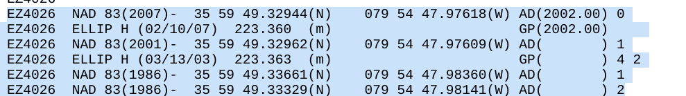
Below are data sheet snippets for an old reliable NGS mark in Guilford County, NC. It’s easy to find and, other than crustal motion, it has stayed put.
Notice how its position has changed from NAD83(1986) to NAD83(2011). The ellipsoid, GRS80, has not changed. The position of Lucy (EZ4026) on that ellipsoid has been adjusted. The point has “moved,” the ellipsoid has remained unchanged. If you plot Lucy’s current coordinates on both the GRS80(1986) datum and on the GRS80(2011) datum, the point will be in exactly the same place on both projections. The same thing will be true if you plot Lucy’s (1986) coordinates on both datums.
That’s because the datum, the ellipsoid and its position in space (See: https://www.ngs.noaa.gov/CORS/Articles/SolerWGS84%28G1674%29-to-NAD83%282011%29.pdf and note “origin” in paragraph 2), did not change.

The GRS80 ellipsoid only cares that your point has GRS80 coordinates. It doesn’t care whether the coordinates were determined by voodoo in 1986 or voodoo in 2010. It will properly display both.
The same thing is true for the original WGS84 datum, but later changes have located that ellipsoid in different places in space. Thus, old coordinates will not plot properly on later incarnations.
GRS80 is an international ellipsoid that was not derived from NAD(2011). Instead, NAD(2011) adjusted coordinate values to position them better on the GRS80 ellipsoid, given more current positional data from a variety of sources.
It can all be made to fit if you hit it hard enough!


Log in to reply.