
Activity Feed › Discussion Forums › GNSS & Geodesy › Source for GPS observation files
Source for GPS observation files
Posted by geeoddmike on November 14, 2019 at 3:49 amGiven that the thread “Static GNSS Survey question” has lost focus, I create a new topic.
Those wishing to explore the result of session lengths (how much time) on the accuracy (or precision) of GPS processing can access observation files and associated data made during the 2011 Texas geoid-slope validation survey here: https://geodesy.noaa.gov/GEOID/GSVS11/data/long-session-gps.shtml
This is a response in that thread that I upload the data file I used to generate OPUS (static) solutions using a range of lengths to CORS. I choose no to do so.
The RINEX observation files I’ve examined had their headers edited to include receiver and antenna make and model as well as ARP values.
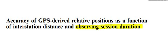
To re-irritate the issue, I find the formal specifications for receivers to be meaningless. The reduction of GPS observations to vectors do not show the length-relative error these specifications use. The Mark Eckl paper here: https://www.ngs.noaa.gov/CORS/Articles/Time_v_Distance.pdf is a more accessible version of his paper published by the J of G here: https://geodesy.noaa.gov/CORS/Articles/Accuracy.pdf
I don’t know who and how these specifications e.g. Trimble R12 is said to have a vertical performance of 5mm + 0.5ppm are implemented by users? It seems to me that some are using this type specification to mean that they do not need to adjust their data.
mathteacher replied 4 years, 5 months ago 10 Members · 28 Replies- 28 Replies

I note that their plots start at 25 km and 1 hour. I’d sure like to see similar data for times in minutes and distances 0-25 kilometers.
.
I recently used OPUS with some data I had handy. I chose the CORS for three submissions of the same data. I chose sites to explore how solutions changed with increasing average lengths to CORS. The average lengths were: 136 km, 1,670km and 2,054km. The shortest length was 31km, the longest was 2,227km. My ellipsoid heights for the three solutions were: -25.087, -25.091 and -25.092 (all meters and NAD83(2011).
I am interested in what you posted in the other ‘Static’ thread. The entire length W–>E of continental USA is approximately 4000 km. If what you are saying about GPS accuracy is correct, then why are there so many CORS established across the USA?
Based on your observation data sent to OPUS, observation length was around 6 hours. If you could get a fix for a 2000 km baseline in just 6 hours of static data then shouldn’t the NGS just established maybe 1 CORS somewhere in Kansas or Missouri? Why the need to establish 2000+ CORS?

As I recollect, the Eckl study used CORS data therefore baselines less than 25 km were unavailable. At the time of the study, CORS required two hours (but could be used with one hour).
Of course height determinations over short distances are best performed with traditional terrestrial leveling techniques. Over short distances my experience is that the best result is via an L1-only solution due to common errors and reduction of the noise introduced by frequency combinations.
I do not recollect any studies using short baselines and short session lengths along the lines you find of interest. Perhaps there is something regarding OPUS-RS? Such research might/probably exist/s.
Do a Google Scholar search or check out some of the research posted on university or GNSS-oriented web pages (e.g. FIG conference proceedings., The Ohio State University, UNB, etc).
I recollect a discussion in the early days of the NGS CORS network where an eminent scientist stated that only one site was needed for the entire country. His point being that such a system was possible. Consider the small set of sites used create and update the ITRF. The NGS plans for a FOUNDATION CORS (?) show how relatively few sites are needed to deliver a reference frame for the U.S..
The decision to pursue densification was to serve users whose desire for short session times required more sites. Dense networks for purposes like geophysical research/monitoring are unique applications. There remain challenges to using GPS for heighting, mainly the wet tropo. Using closely located sites increase the likelihood of common impacts; long sessions allow the impacts to be randomized.
Hope this is responsive,
DMM
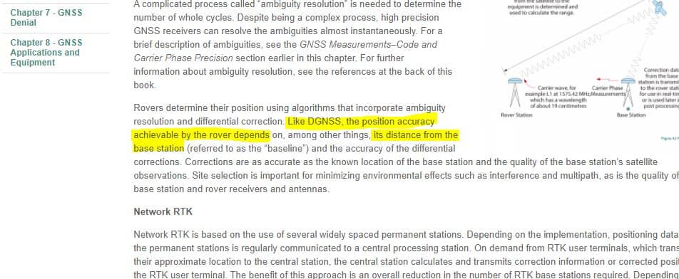
I like the Leica discussion of real-time RTK. I note the proviso that “…among other things the distance…” is important. I did not address my comments to techniques other than static GPS.
As the Leica document states, ambiguity resolution is critical. Obtaining enough data for the determination of these unknowns is a function of time. With more signals and good SV geometry less time is required.
I invite correction as I have limited experience with RTK. Does not RTK rely on correctors being supplied by a base station with the base observing longer sessions. Issues like latency, radio interference are also factors.
See my reply to Bill93.
I nonetheless make one last try to clarify my objection to the adoption of these receiver performance specifications as meaningful guides to field operations (planning and conduct of field surveys).
Perhaps I am being pedantic but stating that an individual receiver can obtain a vertical precision of say 3mm + 1 ppm is invalid in the sense that it is only one element in positioning. It should always be remembered that this is also with respect the determination of an ellipsoid height.
As the specifications add reference to their specs being contingent upon good SV geometry, no multipath, no unusual tropo, no abnormal iono, no setup errors, no SV errors, no site obstructions, no electronic interference, etc. they should be taken as a “rule of thumb” and not tabulated as a rule dictating field operations. I would also add that large errors result when different antennas are used without correction for their different performance.
Does the spec of 3mm + 1 ppm for a 10km baseline (3mm+10km/1ppm = 0.013 m) mean that if I need to obtain a vertical accuracy of one cm (0.01m) that I must add an additional setup? (I neglect confidence levels here).
Blindly using this specification, I would expect a vertical precision of 0.003 m on a 250m baseline and a 0.253m on a 250 km baseline. On the shorter baseline it is too optimistic; on the longer baseline too pessimistic with respect to expected results using appropriate session durations.
You might find this of interest at least with respect to “short” session durations.
 Posted by: @jt50
Based on your observation data sent to OPUS, observation length was around 6 hours. If you could get a fix for a 2000 km baseline in just 6 hours of static data then shouldn’t the NGS just established maybe 1 CORS somewhere in Kansas or Missouri? Why the need to establish 2000+ CORS?
If you have to ask those questions, especially after the patient, lengthy and informative replies by other posters to your previous, almost-troll-level line of questioning, you should not be performing professional-level work with satellite positioning equipment.
Your insistence on distance error plus PPM as the end-all, be-all of satellite positioning is akin to reasoning that a total station is always, under any and all conditions, good to 2mm + 2 PPM, because the spec sheet says that’s what the EDM can do.
By that logic, we should be able to drop a total station on top of the control point without a tripod or tribrach, prop up the prism with a rock near the backsight, perform a station setup routine, and expect to check to another control point within 2mm.
Do you disregard centering error, measure-up error, pointing error, levelling error, target error, atmospheric corrections, circle reading error, and collimation error when performing total station work?
“…people will come to love their oppression, to adore the technologies that undo their capacities to think.” -Neil Postman- Posted by: @rover83
If you have to ask those questions, especially after the patient, lengthy and informative replies by other posters to your previous, almost-troll-level line of questioning, you should not be performing professional-level work with satellite positioning equipment.
I asked that question because the poster said that it doesn’t matter how LONG your baseline is as long as your observation period reaches 6 hours or more then you are going to get accuracy in the <1cm level as he suggested by his example. The fact that anyone believes that you will get sub cm levels for baselines of 2000 km means that they have not been doing professional surveying using survey grade GPS.
Posted by: @rover83Your insistence on distance error plus PPM as the end-all, be-all of satellite positioning is akin to reasoning that a total station is always, under any and all conditions, good to 2mm + 2 PPM, because the spec sheet says that’s what the EDM can do.
And yet that is what he says his GPS is capable of doing. What I said it that you could NOT get any better than what manufacturer’s specs are saying. When conditions are right, you could get better than that specs. If that is ok for your purpose then use it. The specs is a statistical number that says 95% of the observation data is within that accuracy window. BUT the big BUT here is that it is a statistical number. Getting same length for 95% of all observations does not mean that the length is the correct length. The length itself already has systematic errors brought about by satellite positions, signal strength or whatever systematic mathematical errors that are present in the system. All that the RMS results is saying is that you are getting 95% of the same length or position readings, INCLUSIVE of all the systematic & instrumental errors.
Posted by: @rover83Do you disregard centering error, measure-up error, pointing error, levelling error, target error, atmospheric corrections, circle reading error, and collimation error when performing total station work?
Do you disregard clock error, ionosphere error, ephemeris error, trophospheric error, receiver noise error? You mean every time you make an observation, those errors are the same? Or there are no such errors?
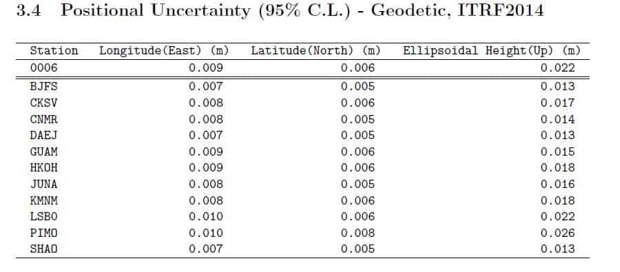
So to test your argument that as long as you have a long enough observation file, you would get the same coordinates from anywhere in the world. So I submitted both to OPUS & AUSPOS. Both used a common CORS PIMO aside from several other CORS based on their summary. Observation length was around 9 hours. I got a deviation in horizontal position from the 2 summaries of about ~1 meter. Vertical ellip height was off by 1 cm. Distance of PIMO to point is less than 170 km. And all 3 CORS used by OPUS were less than 1000 km from point. AusPos used 11 CORS but did not give distances from CORS used in the summary. It gave coordinates but I did bother to compute length to point.
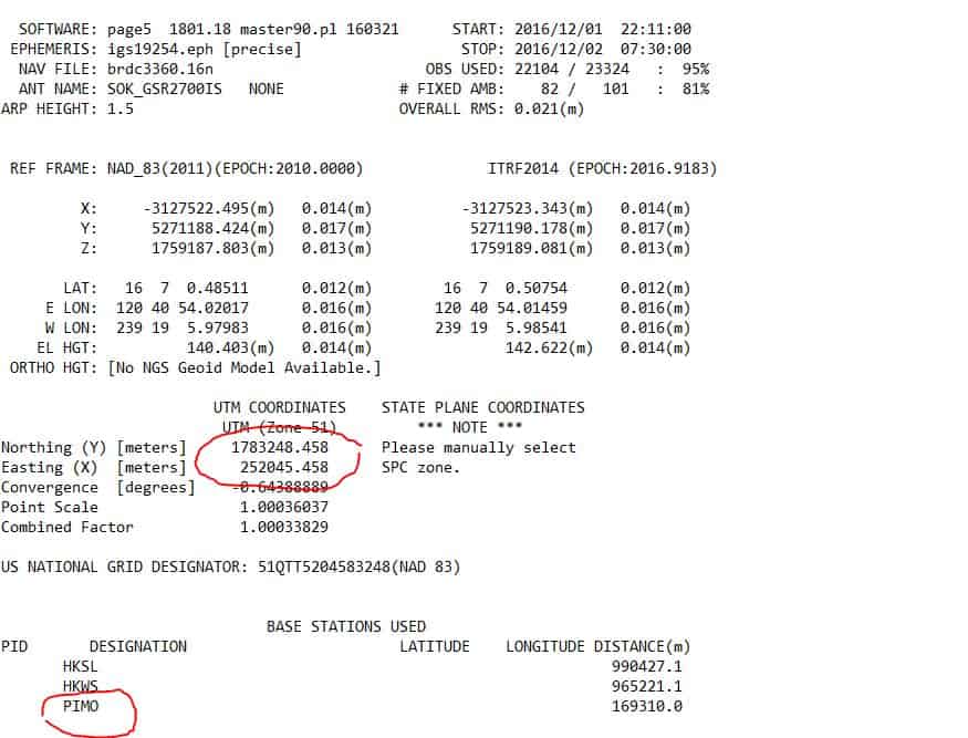
And the 95% uncertainty in AusPos all have them in cm levels. I think this is where you think that because the 95% uncertainty level is in sub cm levels you think that the positional accuracy is also in the sub cm level.
Making a rough computation for the CORS used within the 1000km radius and converting this to PPM, you would get an error circle of 1m which more or less is the difference between AusPos & OPUS.
Just a quick analysis on my part.
- Posted by: @jt50
I asked that question because the poster said that it doesn’t matter how LONG your baseline is as long as your observation period reaches 6 hours or more then you are going to get accuracy in the <1cm level as he suggested by his example. The fact that anyone believes that you will get sub cm levels for baselines of 2000 km means that they have not been doing professional surveying using survey grade GPS.
No one said what you are saying they said.
Posted by: @jt50And yet that is what he says his GPS is capable of doing. What I said it that you could NOT get any better than what manufacturer’s specs are saying. When conditions are right, you could get better than that specs. If that is ok for your purpose then use it. The specs is a statistical number that says 95% of the observation data is within that accuracy window. BUT the big BUT here is that it is a statistical number. Getting same length for 95% of all observations does not mean that the length is the correct length. The length itself already has systematic errors brought about by satellite positions, signal strength or whatever systematic mathematical errors that are present in the system. All that the RMS results is saying is that you are getting 95% of the same length or position readings, INCLUSIVE of all the systematic & instrumental errors.
1. He did not say that.
2. This is a bowl of (technical) word salad.
Posted by: @jt50Do you disregard clock error, ionosphere error, ephemeris error, trophospheric error, receiver noise error? You mean every time you make an observation, those errors are the same? Or there are no such errors?
This has already been addressed in previous posts. Gish Galloping works better in real life than on the web…
Posted by: @jt50So to test your argument that as long as you have a long enough observation file, you would get the same coordinates from anywhere in the world. So I submitted both to OPUS & AUSPOS. Both used a common CORS PIMO aside from several other CORS based on their summary. Observation length was around 9 hours. I got a deviation in horizontal position from the 2 summaries of about ~1 meter. Vertical ellip height was off by 1 cm. Distance of PIMO to point is less than 170 km. And all 3 CORS used by OPUS were less than 1000 km from point. AusPos used 11 CORS but did not give distances from CORS used in the summary. It gave coordinates but I did bother to compute length to point.
That wasn’t anyone’s “argument”. You have been, at various times, jumping to conclusions, pulling statements out of context, mischaracterizing results to “prove” your point, ignoring other posts, over-generalizing, and cherry-picking data.
Two different processing engines, using different control stations and different methods of determining final coordinates, came up with different results. There was a single common station. One. If you think that means the two results will be exactly the same, you really need to read up on how AUSPOS and OPUS analyze baselines and compute final coordinate values.
Posted by: @jt50Just a quick analysis on my part.
This is not analysis.
“…people will come to love their oppression, to adore the technologies that undo their capacities to think.” -Neil Postman Another thread driven to irrelevance by troll-like posters. I appreciate Rover83??s acknowledgement that the statements attributed to me are not correct.
My last post on this thread is surprise that anyone would ??analyze? GPS processing results (3D) by referencing UTM coordinates (2D)??? This in context of a argument regarding the use of GPS for heighting. Sheesh.
Where??s the ??ignore user? option?
- Posted by: @rover83
No one said what you are saying they said.
The poster stated:
Those wishing to explore the result of session lengths (how much time) on the accuracy (or precision) of GPS processing can access observation files and associated data made during the 2011 Texas geoid-slope validation survey here: https://geodesy.noaa.gov/GEOID/GSVS11/data/long-session-gps.shtml
The reduction of GPS observations to vectors do not show the length-relative error these specifications use. The Mark Eckl paper here:https://www.ngs.noaa.gov/CORS/Articles/Time_v_Distance.pdf is a more accessible version of his paper published by the J of G here: https://geodesy.noaa.gov/CORS/Articles/Accuracy.pdf
The title of the paper is
,
Posted by: @rover831. He did not say that.
from his post
If I take GPS data and process using OPUS first specifying close sites and then processing using distant sites, I do not see a correlation due to distance to the CORS. I see a correlation between length of session and precision.
Posted by: @rover832. This is a bowl of (technical) word salad.
I just replaced techical jargons for GPS to your jargons for total stationPosted by: @rover83That wasn’t anyone’s “argument”. You have been, at various times, jumping to conclusions, pulling statements out of context, mischaracterizing results to “prove” your point, ignoring other posts, over-generalizing, and cherry-picking data.
I just made my own computation same as the poster did with his 3 OPUS results.
Posted by: @rover83Two different processing engines, using different control stations and different methods of determining final coordinates, came up with different results. There was a single common station. One. If you think that means the two results will be exactly the same, you really need to read up on how AUSPOS and OPUS analyze baselines and compute final coordinate values.
You know how ridiculous that sounds? It’s like saying to get the same distance, all surveyors should buy the same brand of total station, or to get the same elevation, all surveyors should buy the same brand of level.
You are now saying that using a USA or EU or Asia made GPS receiver and making observations in Australia would yield different accuracy results? different branded gps receivers would give different position results when used in other countries? you do know that CORS are just gps receivers that collect continous gps signals right? Or that Bernese Post Processing or RTKLib can’t be used for other countries GPS data except for the country that developed it?
You are also aware that both OPUS & AUSPOS use the industry standard RINEX file format for gps observations right?
- Posted by: @jt50
You know how ridiculous that sounds? It’s like saying to get the same distance, all surveyors should buy the same brand of total station, or to get the same elevation, all surveyors should buy the same brand of level.
You are now saying that using a USA or EU or Asia made GPS receiver and making observations in Australia would yield different accuracy results when used in other countries?
…aaaand I’m out.
 “…people will come to love their oppression, to adore the technologies that undo their capacities to think.” -Neil Postman
 Will accuracy improve if the UTM coordinates were converted to lat/long/ht? Will the points from AusPos coincide with that that from OPUS if we use WGS84? You are now saying that accuracy will improve/worsen if the coordinates are given in geodetic or projected coordinates?
I appreciate Rover83’s acknowledgement that the statements attributed to me are not correct.
See the post below where I copied what you said from your previous posts.

It appears you are comparing NAD83 (2011) UTM to ITRF2014 UTM.
Difference between wgs84 and itrf is in the mm range with height reaching approximately 15mm
You have an NAD83 (2011) epoch 2010.0 UTM coordinate from OPUS circled on your post as well as an ITRF UTM coordinate from AUSPOS. If you want to make a valid comparison use ITRF XYZ from OPUS and ITRF XYZ from AUSPOS

I use WGS84 for everything because my locations are just above sea level and I don’t have to worry about my distances varying from what my data is in comparison to someone at much higher elevations.
Problems of having different results come from using the wrong datum for your location and being too far away from the controlling monuments and not taking that range into consideration.
The difference between WGS84 and UTM would be the directions. WGS84 is true directions and UTM are grid directions.
Your GPS coordinates will be determined according to whatever datum you select for them to be on your collection unit.
You do know that difference between wgs84 and nad83 or grs80 to be exact is less than 1mm?


Log in to reply.