
Activity Feed › Discussion Forums › GNSS & Geodesy › Static GPS note taking
Static GPS note taking
Posted by brad-ott on January 15, 2022 at 4:53 pmI want a simple electronic (no more paper pencil pen) way to take proper field notes for my upcoming static gps experiments.
Maybe I will just send myself an email for each setup from my iPhone with critical data for each setup.
Is there a simple digital form or an app or something that will prompt me to not forget critical data at each setup?
In a different thread, Nate said he writes down the following for each setup:
??Write down slant height.
Reciever number
Start time
Stop time
And point description.
This way, all correct vectors will close with tight tolerances.
N?
Thanks,
Brad
rover83 replied 2 years, 3 months ago 15 Members · 19 Replies- 19 Replies

I suggest looking for an App that will start a static session. That way you apply all the information directly to the static log file.
You need
- antenna type
- antenna height (suggest using fixed 2m poles if possible)
- point ID
- point description
- start time
- end time
- receiver id or serial number

Measure HI’s in ft and m.
Your phone probably has a note taking function, fill out the information and email it with photos.
I used to have a sheet for static set-ups, there may be a way to set one up in the phone.

Sounds like we can build up one, maybe I’ll play with this in the GIS area and populate and have you test.

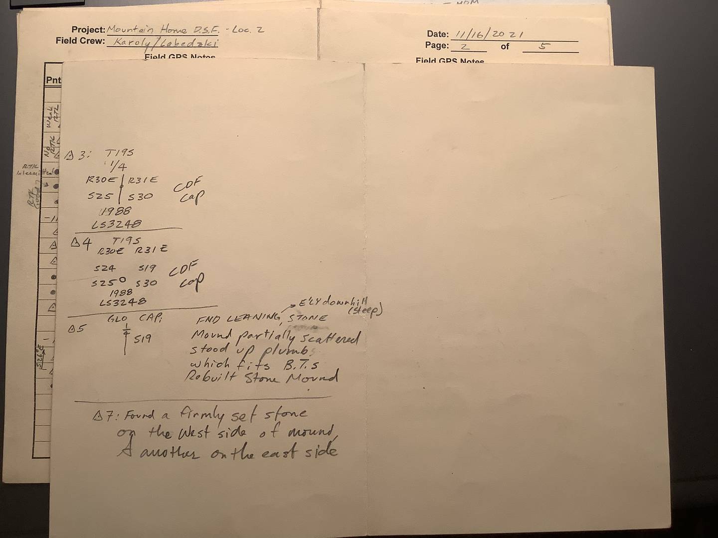
I write notes on a card stock form that I fold in half. Write on the back too. It fits in a level book which functions as note storage and a hard surface to write on.

 Posted by: @mightymoe
Measure HI’s in ft and m.
It amazes me the number of firms that do not do this!
As to the original question. We have tried a couple of different methods of electronic methods, and have quickly abandoned them. A paper printout of the spreadsheet is transfered to digital format by snapping a picture at the end of the day.
A couple things we have added to our list is Hi at start and end of session. And a checkbox to confirm the receiver is still centered over the point. You would be amazed!
Everything else can be pulled from the receiver file, but Hi and centering are hard/impossible to confirm after boxing up!

Speech to text converter.

Please share your forms and formats here, like Dave did (even if they are photographs of paper).

Reminds me of doing pencil rubbing on monuments so that the office knew I was on the correct point. Additional info we use to log. At beginning of session besides the above: number of sats. Pdop vdop etc. halfway through once again and towards end of session. Wet and dry bulb temp pressure correction. Weather conditions. Especially if we saw lightning or a storm front way in the distance. Lightning could cause cycle slips. Also the long antenna cable not coiled up noted. If we keyed a cb or wLky talky noted at what time. I would think if you built a pdf or spreadsheet with all info you require it could easily be used on a phone or tablet or laptop if you are against paper. I like digital copies but love a book or paper. Just take a bunch of different ideas from paper notes and when you find the look and feel Find some young coder and say make this as an app or program that keeps it digital. Sounds like a good project for a STEM at the local high-school or ffa or 4h to do two things. Get what you want and introduce the profession to the next generation.

What??s wrong with a field book? Once you do it a couple of times the format is stuck in your head. Measure HI before and after. Check bubble before and after just like any setup. Close photo, horizon photo.
I know Lee likes the 2m pole setup so he doesn??t have to worry about his HI. But I like the stability of a tripod and the accuracy of the tribrach for centering.
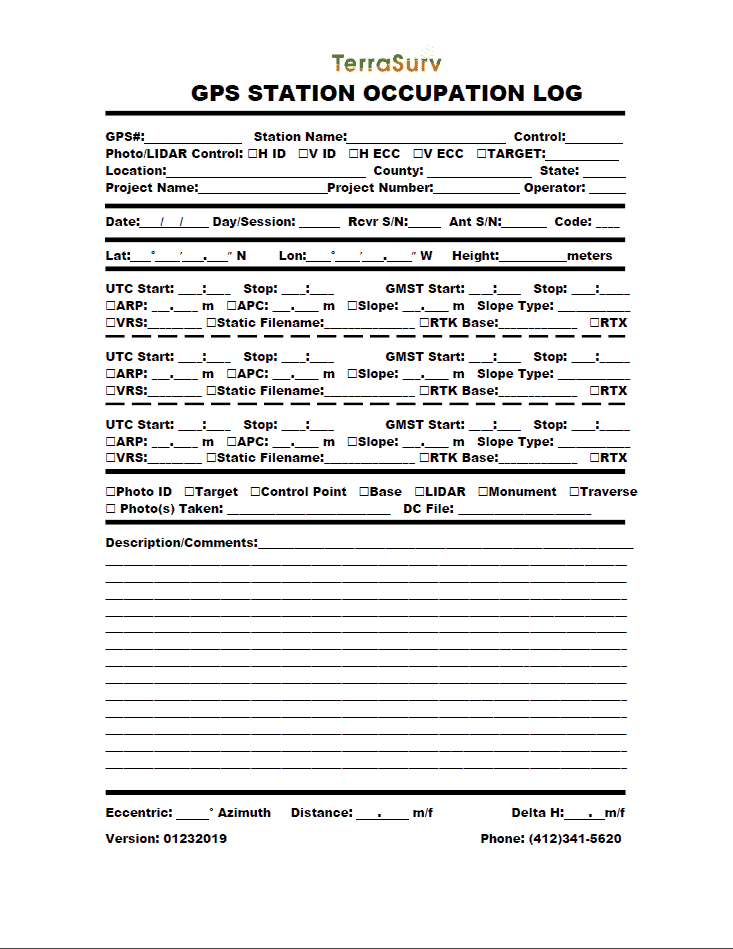
Station:
Receiver Type and Serial Number:
HI:
Start Time:
End Time:
Any other notes about the setup:


If you’re looking for a digital format what you could customize you could use a google form with all the info you’re looking for. Then the results would be available in the spreadsheet created from said form. You could access the information from the spreadsheet as necessary. I’m guessing you could then create a PDF from certain results in the spreadsheet if you’re looking to go back to hard copy from a digital format.
Side note: UAV flight programs have begun integrating forms like this for safety checks and can be set up by the user. We use ESRI’s Site Scan application which allows for custom safety forms to ensure that everything is checked out prior to takeoff. This sounds like a similar situation.

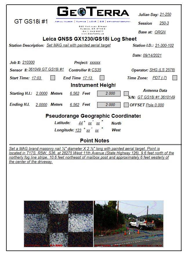
I have been using a form similar to the attached since the 1990’s. I used to print these on paper and then fill out in field. For a number of years now I have filled them out on a laptop/tablet in the field. This is a display form, however the software is a database program and I then merge that data into a different database for final reporting that brings over the photos and the description to merge with final coordinates, etc.
A number of the fields on this form have pull down lists with all the repetitive data such as all my LS numbers, all the SN of all my my equipment, all the short descriptions, etc. In the field I can also duplicate a record and then just edit the changed info, greatly speeds up notes on second occupations which usually only has a different date and time. Date is auto populated from the PC. The check feet box is auto computed from the input meters, you can see instantly if a blunder was made.
All but the photos are done in the field and even those could be done, but that part is a manual process so I usually do it back in the office. At a minimum each evening I rename each photo with a point number so if I add the photos at a much later date I can easily identify which point number and photos belong together.

The NGS field survey forms are a good place to start. You may not need every single data bit on there, but when I had to come up with my own in-house form I started there and optimized it for the work we were doing.
The visibility obstruction diagram is one of the most under-utilized forms for static.
I also still take the NGS 3-photo combo and, like Shelby, always always always rename photos right away. If you are allowed use a whiteboard to help keep track.
Fixed-heights are nice because, even though they can be a pain to adjust and heavy/bulky, when you take those photos you can see exactly what height they are set at.
“…people will come to love their oppression, to adore the technologies that undo their capacities to think.” -Neil Postman
For 34 years since I started doing GPS in 1986 (it was all static back then) I used paper log sheets. I developed many different formats over the years, but here is the last I used…2 sided, sketch on the back…
I would then scan all of the log sheets in a sheet feed scanner.
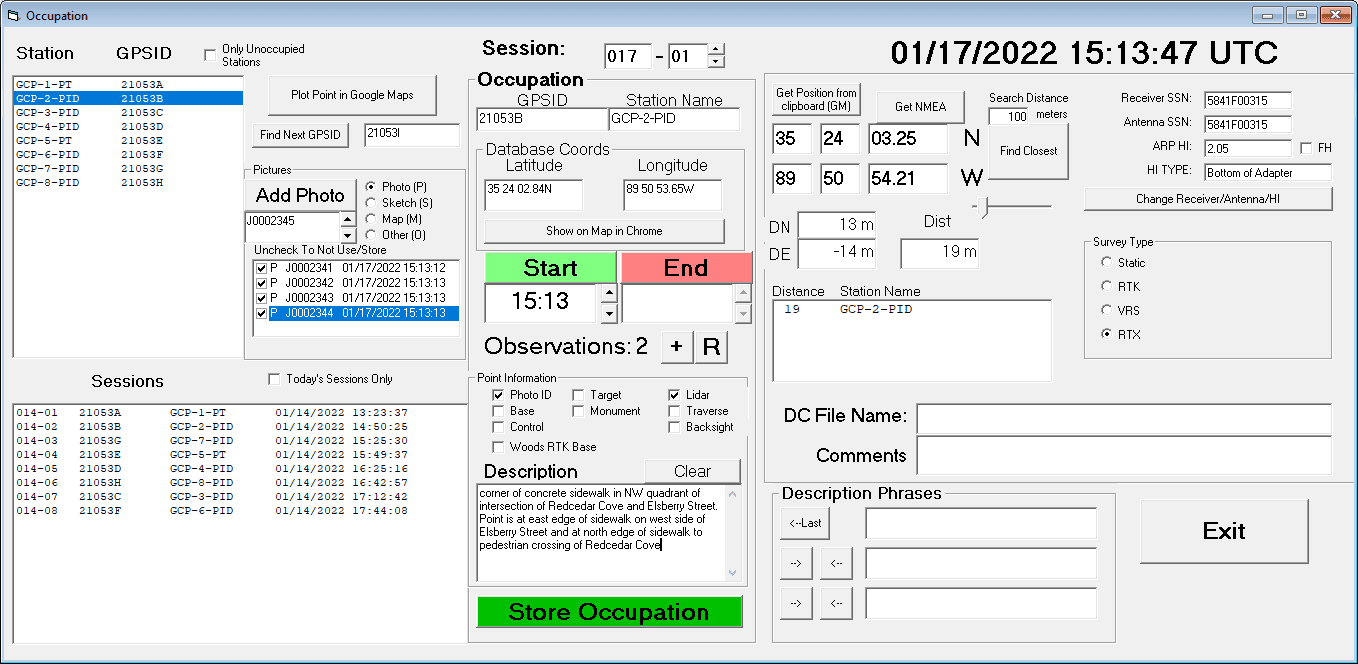
During early COVID when I was pretty much stuck in my office I developed a fieldlog program to run on our laptops. We always have a laptop running when we are out doing static GPS or VRS or RTK for photo/lidar control. It puts everything into a MS Access database, which I can then scan in the office to check for wrong names, etc. And it automatically renames the pictures, and checks the picture times against the field times. We do very large Lidar projects several times a year, with up to 1000 or more points. So it is very important to have a way to check the names, make sure the pics are correct, etc. We also run global mapper with a GPS hooked up, so we can check the position in the field, I have caught myself at the wrong intersection several times when out in the upper midwest where it all looks the same. Once I select a station (either in the Station list on the left or using the “find closest” button on the right), I can view a local map in chrome. This will work with static, RTK, VRS, or RTX. For static it automatically assigns the next file name, for RTK and VRS it prompts for the base name or VRS name.
Here is a screen shot of the occupation screen…
I should add that we still do a sketch, but now on a smaller sheet that comes in pads of 100 and are double sided. I recently bought a digital notepad (remarkable.com) that I am going to try out.
Funny story…around 1990 I was helping another company do a bluebook project. I got a log sheet, filled it out the way I wanted it with a sketch, and wrote SAMPLE diagonally across the sheet, made copies, and gave each operator a copy to guide them
The first day one guy turned his sheets in and he had written SAMPLE diagonally across all of his sheets.
 Posted by: @leegreen
antenna height (suggest using fixed 2m poles if possible)
I really wish Leica wouldn’t have the alternative 1.8m option also on their poles, instead of just 2m.
I can’t figure out why they would do this. It’s such a minor difference, and any time I have 0.6-0.7′ discrepancy in checks I shake my head and wonder if some used the wrong HI
@jph That is fairly new thing with Leica, the slide pole I think is actually also sold as the prism pole? I have one of the newer ones and I have to mentally check it is locked at 2m every set up. With my old Leica 2m (two piece rod), it was ONLY two meters when screws together. With that one you had to verify it hadn’t unthreaded a few mm.
SHG
We used these on all of of static network and LDP network creation stuff.
I even used a wet bulb temp.
Yeah. I’m a dork.
I’m not a fan of the 1.8m either…although for the Seco fixed heights I actually like 1.5m more than 2m, especially on rough terrain. When the three tripod legs get close to fully extended they tend to flex more than I would like. Sandbagging does help but if I’m leaving a unit for an entire day I want it as close to bombproof as I can get.
Posted by: @jitterboogieWe used these on all of of static network and LDP network creation stuff.
I even used a wet bulb temp.
Yeah. I’m a dork.
Me too. All that “extra” stuff is useful when troubleshooting big networks and chasing tight tolerances.
Even when I didn’t have to fill out an obstruction form, I would just write it in the field book next to the observation info. Takes all of 2-3 minutes with a compass/clinometer combo and jotting down a few lines “Treeline @ 75m, 20?ø incl, 235?ø Az.”
“…people will come to love their oppression, to adore the technologies that undo their capacities to think.” -Neil Postman


Log in to reply.