
Activity Feed › Discussion Forums › Photogrammetry, LiDAR & UAS › Accuracy of Drone Surveying
Accuracy of Drone Surveying
Posted by eagle1215 on August 14, 2021 at 1:48 amI don’t know much about drone surveying and I have only worked for a surveyor for a year. I was at an EAA (Expieremental Aircraft Accociation) chapter meeting and the topic of the meeting was the Fort Wayne Police’s use of drones and how they affect fixed wing aircraft. There was a segment on mapping accidents and crime scenes. Their procedure is that they use two of their control points in photographs with other software to map the scene (not LiDAR).Their claim is that they are accurate to 0.01 to 0.02 feet. Theoretically I would belive it, if the world was perfect. I don’t understand how you are able to have a GPS based unit (accurate to 0.05 to 0.1 on a good day) and hovering in the air that is more accurate than what I can do on the ground. I asked questions, but they only knew how to operate the drone and not the theory behind it. Were they blowing smoke or correct?
bill93 replied 2 years ago 19 Members · 27 Replies- 27 Replies

If they have only 2 pts to determine the scale of the photo…that would make them meas the same as the photo scales….its like say two points are in a straight line


If you have only been Surveying for a year and understand their thinking is fundamentally incorrect. We are hiring. Are you looking for a better place of employment? Haha. Several others smarter than me will give great info

I don’t have an authoritative answer to your question but I share your skepticism. They aren’t going to measure anything off photography to a degree of accuracy greater than the precision of the control marks. Probably they are making the typical mistake of equating readouts to 2 decimal places with precision at the hundreths level.
Nevertheless, photogrammetry can have accuracies that closely approach those achievable with the total station. That should be more than sufficient for accident and crime scene investigation.

There’s a reason surveyors spend time learning about error propagation and the difference between accuracy and precision. Search the web and you can find some peer reviewed studies on verified accuracies of drone surveys. The short answer is it depends on numerous factors not limited to altitude, brightness, camera size, camera angle, accuracy of ground control points, and wind speed. You could measure the same sight on a cloudy day and a bright sunny day and get different accuracies. The texture and variability of the surface being mapped is also important. If the AOI is a grassy lawn with few unique features, the might struggle if only two GCP were used. I’ll never have time to do it, but I’d like to compare drone mapping of a given length of unmarked asphalt with the same section having irregularly shaped colored tinfoil, or glitter or something biodegradable scattered throughout. Maybe you could hop on a four-wheeler and drive around spraying party string throughout a site?

@eagle1215 what ken is eluding to is that any two points will make a line, but you cannot test the constraints of the points compared to the rest of the world because, well, you only have two points.
It’s like a surveyor finding two pins on his property and running with it because it measures the deed distance. That’s nice and all, but my favorite surveyor, Johny Two-Pipes, could have set them with just a tape measure.

So many things I want and could say here….
First off there is no way they are really achieving those accuracies. What they are stating is that they are locating two control points- more than likely via VRS observations, and the digital photogrammetry software can mensurate the straight line distance with collected images to agree within 0.01-0.02 (remember, anyone can stretch data to match two points, which is why you always take that check shot when you set up your total station). What they are telling you is that the software can force the collected images to match the measured distance to that level of accuracy. This does not mean the entire scene is that accurate. You should have immediately asked them if they achieve those same levels of accuracy if they add a total of 3-5 control points. And then followed up and asked how the data compared to multiple independent check points.
Second, to achieve GNSS observations anywhere even close to that one would need to occupy the point for 8-12 hours (or longer) and would observe more than once and perform a lease-squares adjustment.
Third, there is a difference between relative and absolute accuracies and these two are so often misunderstood.
You seem like you are interested in this topic. You should do some research and read up on ASPRS standards and read up on Root Mean Square Error (RMSE) and then ask yourself if the EAA group are using best methods and if they can measure two point to the level of accuracy to achieve 0.01′ when tested at 95% confidence level.
Photogrammetry is a solid and proven method. But it also requires great care and skills to perform.
I have used sUAS for mapping and inspections through both digital images and LiDAR and do so daily. I would guess they needed to move that decimal around some on their stated accuracies. Don’t drink the salesman’s KoolAid.
 Posted by: @eagle1215
I asked questions, but they only knew how to operate the drone and not the theory behind it. Were they blowing smoke or correct?
Well, if they only know how to operate the drone, it’s pretty much a slam dunk that the only thing they should be trusted to do is exactly that. As others have already said, operating the drone is the easy part. Processing of the data and extracting meaningful information should be left to the ones who know both the theory and practical application of such. Every single piece of equipment and software we use operate according to theories. Ignorance of those theories isn’t an option for professionals.
Every time I read about this sort of thing I think about the quote from my signature line. Everyone just thinks they can pay for a software routine to shove data into and magically get a perfect result…because thinking and doing things the right way is too hard, slow, costly, elitist, pointless, etc.
“…people will come to love their oppression, to adore the technologies that undo their capacities to think.” -Neil Postman
I discussed surveying with some police officers. I expressed surprise that they did not use professional surveyors for crime scenes, etc. They were shocked that I would think of allowing someone without a badge to do the work.
Apparently, the traffic cop rotation, which includes a couple of weeks of surveying, makes them into expert measurers. Must be a crazy good school.
My understanding is that the process is reduced to simple rules of thumb to make analysis. There is fancy black box software that will churn out “precise” collision speeds, etc based on deformation of the car body, etc etc. The operator typically has only slightly more than zero understanding. They understand the concept sold by the software/hardware company, but I would venture to say that there has never been independent confirmation.
Apparently, it is good enough to convict people, but I wonder if it is only poor people that cannot afford real experts and fancy lawyers…
-All thoughts my own, except my typos and when I am wrong.
I thank all of you for your response. I am happy to learn that my suspicions were valid.

Drone height accuracy also depends on the surface you are measuring.
Hard surfaces like roads can be to about 2-3cm, but grass areas are about twice or three times that
- Posted by: @dmyhill
I discussed surveying with some police officers. I expressed surprise that they did not use professional surveyors for crime scenes, etc. They were shocked that I would think of allowing someone without a badge to do the work.
Apparently, the traffic cop rotation, which includes a couple of weeks of surveying, makes them into expert measurers. Must be a crazy good school.
My understanding is that the process is reduced to simple rules of thumb to make analysis. There is fancy black box software that will churn out “precise” collision speeds, etc based on deformation of the car body, etc etc. The operator typically has only slightly more than zero understanding. They understand the concept sold by the software/hardware company, but I would venture to say that there has never been independent confirmation.
I had the opportunity to go through a couple geospatial forensics software courses. They were principally taught and attended by police officers, who clearly had somewhere between zero and minimal instruction in practical data collection, error propagation, blunder detection, etc…suffice it to say that a majority of them believed that the badge made them an expert in any subject they cared to hold forth on. Including practical data collection, error propagation, blunder detection, etc…
No one could ever tell me exactly how scan data was gathered, processed, georeferenced, etc.
Someone had to be doing something to get it in the format we were working with, but no one knew what. There could have been gross errors in those datasets, which could influence results determining legal fault and radically changing lives, but damned if there wasn’t much interest in QC.
“…people will come to love their oppression, to adore the technologies that undo their capacities to think.” -Neil Postman 
A surveyor friend of mine has shown me his photogrammetry projects, which appear to be very accurate. Not all projects require a high degree of accuracy but when they do, you need the right equipment and the right understanding of how it works.
Attached is a photogrammetry point cloud and a check shot. The check shot was taken on the corner of the sidewalk with a Leica system separate from the photogrammetry system. The error amount
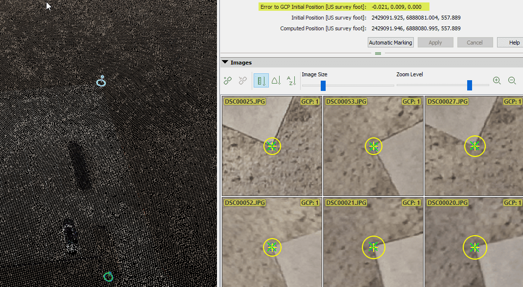
is highlighted. A photogrammetry project with this level of accuracy has a lot of value.
Things to factor in are:
GPS accuracy of the image geolocation, lens calibration, and photogrammetry software.
I couldn’t put the point of a rod on the same spot on a sidewalk corner to less than 0.02′
So that seems pretty good work. I will also offer that if you had a HARD surface you would likely have a much more accurate surface from the drone, perhaps not as precise. In some ways the tech reminds me of when I first started using GPS receivers for long traverses. It is a black box, it is whiz bang, it has lots of great applications, and…it can get you in real trouble real quick.
-All thoughts my own, except my typos and when I am wrong.- Posted by: @outsideoffice
A surveyor friend of mine has shown me his photogrammetry projects, which appear to be very accurate. Not all projects require a high degree of accuracy but when they do, you need the right equipment and the right understanding of how it works.
Attached is a photogrammetry point cloud and a check shot. The check shot was taken on the corner of the sidewalk with a Leica system separate from the photogrammetry system. The error amount
is highlighted. A photogrammetry project with this level of accuracy has a lot of value.
Things to factor in are:
GPS accuracy of the image geolocation, lens calibration, and photogrammetry software.
Is that a true check shot, or a control point residual? A GCP is not a check point, and generally speaking all GCP residuals will look good when you force everything to fit to them.
I’m not saying that this is necessarily suspect, but like any other software program or algorithm, they are only as good as the data they have to work with.
I’m with @dmyhill and @dougie, it’s hard enough to survey a point to that absolute precision, let alone tie a photogrammetry project to that precision.
“…people will come to love their oppression, to adore the technologies that undo their capacities to think.” -Neil Postman 
Rover83 makes a good point. A check shot on or near a constrained point only proves your instrument work is good. You need to sample the areas where the software does its magic, between constrained points. Also hit various colors, shaded areas, etc.
 Posted by: @rover83Posted by: @dmyhill
I discussed surveying with some police officers. I expressed surprise that they did not use professional surveyors for crime scenes, etc. They were shocked that I would think of allowing someone without a badge to do the work.
Apparently, the traffic cop rotation, which includes a couple of weeks of surveying, makes them into expert measurers. Must be a crazy good school.
My understanding is that the process is reduced to simple rules of thumb to make analysis. There is fancy black box software that will churn out “precise” collision speeds, etc based on deformation of the car body, etc etc. The operator typically has only slightly more than zero understanding. They understand the concept sold by the software/hardware company, but I would venture to say that there has never been independent confirmation.
I had the opportunity to go through a couple geospatial forensics software courses. They were principally taught and attended by police officers, who clearly had somewhere between zero and minimal instruction in practical data collection, error propagation, blunder detection, etc…suffice it to say that a majority of them believed that the badge made them an expert in any subject they cared to hold forth on. Including practical data collection, error propagation, blunder detection, etc…
No one could ever tell me exactly how scan data was gathered, processed, georeferenced, etc.
Someone had to be doing something to get it in the format we were working with, but no one knew what. There could have been gross errors in those datasets, which could influence results determining legal fault and radically changing lives, but damned if there wasn’t much interest in QC.
This sounds like a wonderful opportunity to serve as an expert witness for the defense team.
I always thought that specifically marketing to defense attorneys for expert witness services was something that surveyors have never truly exploited. I have been an expert witness probably seven or eight times and I am always amazed at the total lack of any basic knowledge of measurement by the attorneys and courts.

When you are walking between the GCP’s in order to fix them it takes hardly any extra time to pick up additional obvious points as checks – and some non-obvious ones in vegetation areas. Take sufficient of those and you can then “calibrate” your point cloud results for each general type of vegetation so you have correction factors for say, long grass short grass, crop type, light scrub, etc. They won’t be perfect but you end up with a much higher general accuracy to the heights in your ground model. The only real overhead is the time you spend looking at that “calibration” and then applying it.


Log in to reply.