
Activity Feed › Discussion Forums › Photogrammetry, LiDAR & UAS › Iphone 12 has LIDAR
Iphone 12 has LIDAR
Posted by jt50 on October 13, 2020 at 11:36 pmWould love to hear about its LIDAR capability if anyone has fallen in line to buy the new Iphone 12.
ncsudirtman replied 3 years, 2 months ago 12 Members · 21 Replies- 21 Replies

I just ordered the 12 pro max w/ lidar, ATT says 1 week
I need a phone anyway so I did not upgrade for this feature but go to youtube and search for this.
I can see it helping on those detailed topos.
The measure feature looks impressive.

AT&T told you a week. I ordered a 12 pro for my wife and I’m not excepting it until mid December.

I??ve had my 12 for about a week now, just started playing with scanner apps in the past couple days. There aren??t- yet, that I can find anyways- any that will export into a CAD happy file format. Or, I should say, the one that does export DXFs is practically useless in terms of doing anything other than shooting the inside of a closet.
that said- there are a surprising number of apps already out there, it??s clear they??re just not purpose based for OUR purpose. (And now I also understand how all those first person video games can get churned out on a daily basis.) but doesn??t seem like it would take much to bridge that gap.
I??ll try and do some more digging this weekend. But this is exciting to me- seems like it could really make a difference in workflow for certain kinds of jobs.

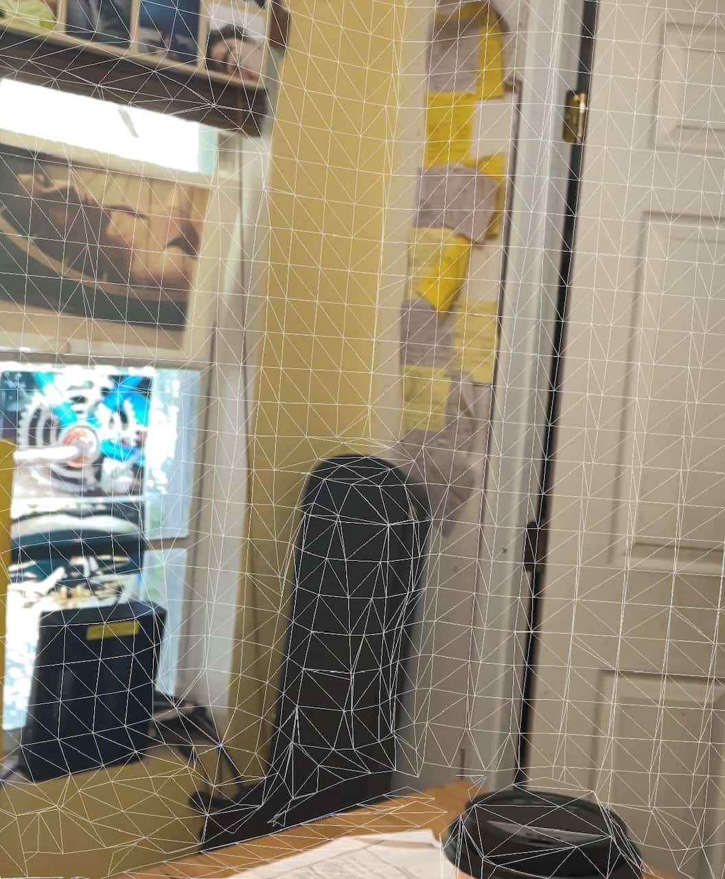
here’s a screenshot from polycam in the middle of a scan with the camera turned off. and another with the camera on. like most i’ve seen, polycam will export OBJ and a few other formats that i’m not familiar with. but no LAS or ASCII export.

the only app i’ve found so far that will export DXF (haven’t found any with point cloud exports) is magicplan, which is some DIY remodeling floorplan app that is heavy on bells and whistles and seemingly useless for any survey related tasks.

Doesn’t Autodesk Recap read OBJ files? Maybe CloudCompare, MeshLab or another free program to import OBJ and export in CAD-friendly format?
I haven’t used those programs for several years but I remember they were pretty great for basic conversions.
“…people will come to love their oppression, to adore the technologies that undo their capacities to think.” -Neil PostmanYeah, reckon it??s time to learn about that end of things. Found this: https://cadexchanger.com/obj
might try that route. Can see workflow with it, would be interested in testing it. Seems like you could get sufficient registration to conventional data and… see. You know? Can??t imagine it would yield less reliable information than what most of us were capable of producing up until the last decade or so, within a particular scope.
have reached out to development department for these guys: https://canvas.io/
so far seems the most survey-ready app i can find. they already have a scan to CAD service, but it’s pricey and clearly not intended for end users who would be working in volume. i could see a subscription rate or them being enlightened that there’s a potential specific market for point cloud exports from the phone app. they claim you can export point clouds, but i can’t yet find it on the phone or any explanation as to how to…
another one from japan is pronopointscan but i can’t yet figure out how to get files out of it, and it’s a japanese developer and trying to get through even their webpage is a little more than what i’ve got bandwidth for on a sunday afternoon.
anyways- this is right around the corner kind of stuff. excited to see how this can expedite my work.
ED: just found the ascii file for pronopointscan. guess i’ll go down the wormhole of trying to get it into CAD.
well, this is clumsy as can be, but it works. won’t be long now…
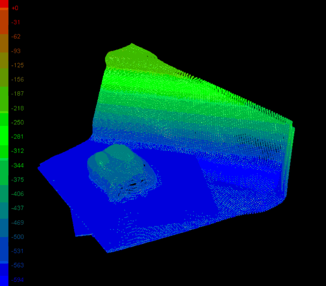
oh, btw- that’s 116 thousand points over a 10-12 ft<sup>3</sup> area.

Leica makes a stereo image device in a phone size that is supposed to do that sort of thing.
-All thoughts my own, except my typos and when I am wrong.
Goodbye DotProduct

I recently received an email from Pix4D advertising a software package designed to be used with the iPhone scanner to collect and build a working point cloud. Almost makes me think about getting an iPhone and getting away from Android… almost…

@flyin-solo Any chance you could detail the used process to export the ascii file from Pronopointscan? Thanks in advance!
all i did was hook up the phone to my laptop, at that point in file explorer you can go into the iphone as a drive and find the ascii files for each scan.
copied the ascii file, opened it in excel, and deleted the last three data fields (guessing they are RGB color values- in any event, it’s clear they aren’t coordinates). save as CSV, import into CAD per usual ascii import.

@andrew-clark I have been thinking the same thing….this might be the game changer for me.

There are apps out there that allow you to do an LAS export from your iPhone. My question to those who see value here, What applications will this be useful?
I watched a webinars that someone would scan with the iphone12, export to 3D Microsoft Builder, scale and cleanup, and then 3D print. This is with all low cost/free products! Pretty incredible.

I had no idea the new iPhone 12 pro did all this as I just bought my wife one & she loves it. Thanks for the info guys. I’ll have to find a way to process the data from the phone
I may try it here soon with her phone vs my Trimble S3 in DR mode as I’ve got a whole pile of mortar sand in the backyard that I’m curious about now haha. guess the kids’ sandbox will have to wait another day ???
where does pronopointscan offer to export the files? I downloaded the app to my wife??s iPhone 12 pro & ran a scan but can??t figure out how to export the point cloud scan? And if so, will any of these file types export into a Civil 3D surface-friendly format?
@ncsudirtman there’s no export option. but… if you go into the “Files” icon on the iphone>(Locations)On My iPhone>pronoPointScan there will be an ascii file of your scan. it looks just like a normal ascii point file, except with different fields (so where the usual might be P,N,E,Z,D this one is- i believe- N,E,Z,R,G,B (or N,E,Z,C,M,Y)). the “R,G,B” being color values. so i took that ascii file, imported into excel as a CSV, and stripped the last three (color) fields out. I added a column at the front and gave the points numbers, then imported that into cad like normal. that’s what you see in the image below. it looks like what i scanned, the dimensions are seemingly correct (the shading you see is the elevation shading toggle turned on for visibilty.)
otherwise, i’ve had exactly ZERO time (maybe even negative time) to play around with the iphone and lidar since this little rabbit hole expedition a few months ago.


Log in to reply.