
Closing Corners
The question for the PLS quiz required calculating the NW closing corner of Section 5.
I take the stance that it needs to be prorated and I have some time this morning to explain more in depth; beyond that’s the way we always do it.
My question asking if the notes have different info than the plat which holds the notes or the plat wasn’t answered, but as many know the answer is the plat holds over the notes. That seems wrong because it’s easy to infer the draftsman made a mistake transposing numbers or it’s a typo in the face of the plat. For example if the notes show 79.96 chains along the south line of Section 5 and the plat shows 79.86 chains do you use the plat or the notes to prorate in the SE section corner. The plat is what is used. One reason and probably the main reason is that the plat is the document used to issue the patents for land. The patentee has every expectation to have the information on the face of the plat honored.
Closing corners are vexing. They weren’t even intended to be placed on the line, only “close”. So the tie to the nearest corner starts out as a hypotenuse and not a tie along the line. So the distance should be shorter than the tie. They didn’t measure to the next corner so you have the closing corner single tied. Can you use the remaining distance along the line to prorate? The answer is yes, you can.
The distance shown on the plat is 14.70 chains, the record along that line is 40 chains, leaving 25.30 to the corner to the west. I prorated in using those distances to get my location,,,,,,,as I always do in these situations.
This seems wrong because of what we know about standard lines being long, the ties being tricky as well.
But that’s not the issue. The issue is the plat and what’s on the face of it. It’s the law also. The law states that these dimensions and information will be held and respected. There really isn’t a choice,,,,,,,,,and it makes it simpler.
You must give up the conjectures, the assumptions, the speculations and protect the plat. By protecting the plat as the law requires you protect the bona fida rights of the land owners. The 25.30 dimension to be used to prorate is protected by law. It makes the decision easier for the retracing surveyor.
Is what I’ve related above correct?
Let us take a real world look.
I know it is since this isn’t my first rodeo, but if you ever have questions about these issues there is a very good resource.
The great retracement surveys of the Powder River basin can help guide you about what to do.
You may have issues with the BLM and their practice, but they know their stuff and I will show a couple of closing corner examples here:
This is the original plat for Section 3; T52N, R70W; closing on the Thirteenth Standard Parallel 6th PM:
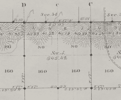
The NW corner of Section 3 ties to The SW corner of Section 34 in T53N, 14.99 chs., the northeast corner of Sec 3 ties to the SE of Sec 34 15.01chs.
The next figure is the resurvey:
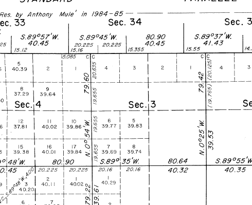
It doesn’t take much calculation to see that the corners are prorated in, using the 14.99, 15.01 chains subtracting them from 40 record chains and using those numbers to prorate against measured.
Doing this protects land owners on either side of the lines.
The notes are available and I suggest if there are ever questions about the correct procedure, Campbell County Wyoming is the place to research. All 5000 square miles have been resurveyed I think. If there are still some original surveys I haven’t been there. It’s a few clicks to get to the web site for the BLM in Wyoming and all plats and notes are there. Be sure to use internet explorer, some other web search engines don’t seem to work very well with the site.


Log in to reply.