
Activity Feed › Discussion Forums › Strictly Surveying › GIS bone
GIS bone
Posted by MightyMoe on August 3, 2022 at 12:57 pmPutting a Lat Long on each Record of Survey that I file is something new. It’s required for Subdivision plats but other plats, corner records and exhibits don’t have that rule. What I’ve found out is that new Subdivisions are quite accurate in the GIS. The Lat, Long requirement is working well, so I’m trying to remember to add a lat, long on a point in each new plat. Is this something that’s a requirement in your local area?
Of course the Lat, long needs to be attached to a basis of bearings and distances that can be easily reproduced by the GIS person.
bill93 replied 1 year, 8 months ago 12 Members · 28 Replies- 28 Replies

Yes, but they like state plane coordinates where I work. It helps the GIS techs get things entered properly into the public systems.

And Metadata . I would rather see Lat and long than spc values. My experience so far when seeing SPC coordinates is now I have to figure out if the scaled them to ground or some other hybrid way of doing it. Hardly do I find they are actually on the epoch and realization of NAD83 that is stated. Some are within a foot or so some greater. But having done both GIS and Surveying I believe Lat Long with Datum info is about the best route. It would not even bother me if one scaled it from a map as long as that was noted.

They require a SPC on subdivision plats, we give them both, however, I figure a Lat, Long is a SPC coordinate. I show them to the third decimal place of a second and the type (NAD83), that’s it.

@mightymoe Knowing how my company’s GIS software works, “NAD83” is likely not precise enough. Is it really NAD83 (2011)? Some other realization/readjustment?
I’m just one of those evil GIS people. Bwah-hah-hah! Seriously, I do coordinate systems and transformations at Esri. Posted by: @mkennedy
@mightymoe Knowing how my company’s GIS software works, “NAD83” is likely not precise enough. Is it really NAD83 (2011)? Some other realization/readjustment?
100%, that’s always my concern whenever I see any sort of coordinate on a survey. There are way too many surveyors who do not understand how to properly cite geospatial metadata, or even what datum/realization/epoch they are actually operating in.
“…people will come to love their oppression, to adore the technologies that undo their capacities to think.” -Neil Postman
My personal view is that this is an abomination encouraging the unknowing to make mistakes they have no clue they are making over and over and over and over again. Leave it to the surveyors to know what is what. The barely educated do not need to be encouraged in this manner.
If this was a requirement, I would round to the nearest degree of latitude and longitude.

your Mileage will vary between the entities.
ESRI has been in a full court press to help the local regional and even national GIS groups to utilize the Parcel Fabric model and tying down the old plats with the new and very precise land survey data to increase the value of the products and support that GIS is able to do.
it’s not getting worse, it’s getting better, however, GISP still isn’t a professional license path yet, and likely will not become one. Hopefully not I’m my lifetime anyway.
Not sure where you are, but NAD83(93) or NAD83(2011) would be irrelevant to this issue. The latest one I’m turning in is NAD83(93), but if I change it to NAD83(2011) the expressed coordinate wouldn’t change or might change one integer in the last digit of the Latitude. The Local HARN point has shifted .1′ in latitude since 93, in longitude even less. I know it’s more of an issue near the coast, but here it’s a slow moving process, the velocities are small.
But, regardless, moving the GIS to something close to “real” is the main task, I don’t care about a tenth or even a foot or two. The problems are the gross errors the GIS is infested with.
I’m only expressing the coordinate to the third decimal place which is .1′ in Lat, .07′ in Long. Rounding might keep it the same 93 or 2011.
The GIS locally has been a problem, even ending up in court and causing heartache and misery in my neighborhood. Getting it better is good, getting it perfect isn’t possible.
- Posted by: @holy-cow
My personal view is that this is an abomination encouraging the
unknowingsurveyors to make mistakes they have no clue they are making over and over and over and over again. Leave it to thesurveyorsGIS techs to know what is what. The barely educated surveyors do not need to be encouraged in this manner.I could easily turn that around. For every GIS tech that doesn’t understand boundary surveying, there’s a licensed surveyor that doesn’t understand geodesy, projections or datums.
The difference is that the tech doesn’t absolutely need to understand boundary surveying to do their job well. Their role is to integrate data points into a database and run data analysis. But the surveyor needs to know about datums to be able to do their job well and give the GIS tech quality data with associated metadata.
There’s always going to be the possibility for our data to be misused or abused no matter what software our boundaries end up in.
But this is how we got here in the first place – surveyors turning their noses up at GIS because “it isn’t real surveying”. The more we dig our heels in and refuse to become part of the solution rather than part of the problem, the more we’re going to get shut out and, ironically, the less we’re going to be consulted when we really ought to be.
“…people will come to love their oppression, to adore the technologies that undo their capacities to think.” -Neil Postman  Posted by: @holy-cow
My personal view is that this is an abomination encouraging the unknowing to make mistakes they have no clue they are making over and over and over and over again. Leave it to the surveyors to know what is what. The barely educated do not need to be encouraged in this manner.
If this was a requirement, I would round to the nearest degree of latitude and longitude.
I agree 100%. Most of the time the GIS gurus don’t have a clue about surveying, coordinate systems, epoch, grid to ground scale factors, monuments, etc. They just want some lats and longs for their system. I’ve worked on creating the parcel database for 3 counties and in each case we surveyed in the primary section corners (we budgeted to pickup the corners in the populated areas). And then we mapped every single parcel in the county. That was 20 years ago and to this day the GIS in those counties is spot on. You can clearly see the counties that took the ‘past the old assessor map drawing approach into GIS and get it fit in to look good approach’
@rover83 You said a mouthful. I think some of it is a self inflicted wound. With statements of things like GIS means get it surveyed! Those younger folks heard that at the same time of hearing things like SPC, GPS coordinates, Grid coordinates and they are good enough for a GIS folks. So inadvertently we created a monster. I was discussing this not long ago over a fresh beverage. The survey manager said all he does is get a lat long from google earth and uses his software to make a spc because thats close enough. No real understanding at all and I believe someone placed a rock in his beverage because he almost choked when I said I would give him a $100 bill right then if he could show me where in google earth the accuracy statement was and which datum it was on.
I am a firm believer that you do not have to have a boundary on a known system. However, it can if done correctly make it easier to retrace in the future and or add more evidence for those following in the future. When done i correctly it causes more harm than good. It is so easy to do it correctly now days that it doesn??t take anymore time to do it right vs good enough.
I am afraid that some fight this and the writing is on the walls that good enough is going to show its ugly head as imagery will only get better resolution and become more accurate in the future. Which will show our peers our lack of understanding or carelessness.
It doesn??t bother me either way if you do or do not show a datum or a Lat long or SPC via grid on a plat or map But if you do state the correct data so one can follow it. You could state NAD83 2010 (2011) and Lat long and or zone for grid values and a simple position tolerance of that like scaled from a 1:50000 map or +/- .25 ft @95% etc etc that allows one to know what to expect when following . No difference of retracing a boundary with a 1:10000 closure statement on it I have an idea of the precision and that is only one small piece of the big picture as the measurements are at the low end of priority of calls.
But i am the one who always states a description of what I find in field as well not just Iron Rod Found but size depth below or above surface condition and if its a rebar pipe etc .
The problem I was referring to is that the landowner can get the LAT/LONG from a friendly GIS worker then drive their vehicle, which might be a farm tractor, to the alleged spot. Maybe then the landowner pulls out his hunting range finder (yards) and starts trying to mark off his property. Stupid people do even stupiderest things because they believe they have all the information they need. Land surveying involves far more than measurements. Why encourage the unknowing to do these stupiderest things?
BTW, you probably won’t find stupiderest in the dictionary. You know, one of those big books with millions of words, all in alphabetical order.

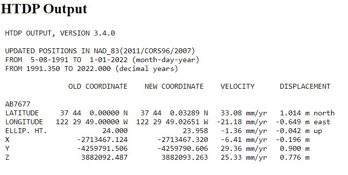
As Melita said, NAD83 alone won’t cut it in California. I did a quick HTDP transformation for a HPGN (HARN) point in the SF Bay area from 1991.35 (original HPGN epoch) to 2022.00. A 3.3′ by 2.1′ shift in that time.
@mightymoe ????. Run Forest run. So surveying where you need to start by practicing catching a greased pig. Once you can catch a pig then you can work on getting accepted to become a surveyor. This whole earth rotating and wobbling and circling around the sun is one thing now we have to deal with plate tectonics and subsidence. I love it just meeps us on our toes and learning all the time.
- Posted by: @olemanriver
now we have to deal with plate tectonics and subsidence.
I have long referred to it as job security.
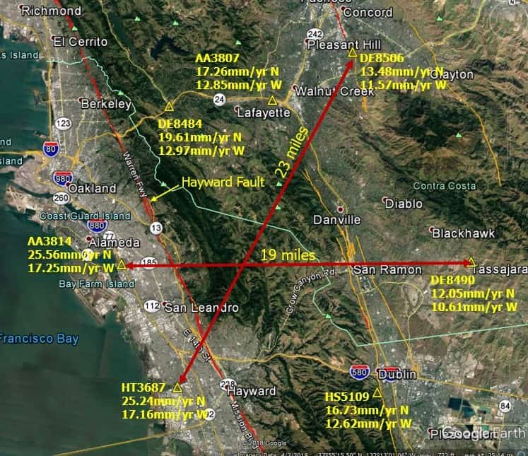
I may have shared this before, but these are the HTDP calculated velocities for several control points in the east SF Bay Area over a relatively small region. Our latest realization of NAD83(2011) is 2017.50, which was produced by the California Spatial Reference Center. Because of the delay in the rollout of the new NSRS, we are contemplating one more realization of NAD83 because 2017.50 has fallen apart in many areas in the western part of the state.
@spmpls wow . Y??all have your hands full for sure. I don??t know if my simple brain could keep up with that much movement. Job security for sure.
Judge: Mr. Expert Witness, explain this to me again. Your survey plat from 1978 says the latitude and longitude of the point in question is X,Y. Your survey plat from 1991 says the same exact pipe is at X1, Y1. Your survey plat from 2022 says the rusty old pipe is now at X2,Y2. Are you inept?

@holy-cow is the Judge using his set of 1970s statute books?


Log in to reply.