
How well does a Javad LS work in the woods?
Off the cuff here??I??m a skeptic??GPS is NOT for woods??but check this out??Couldn’t help but share this:
I have been working with a Javad Triumph-LS and Triumph-2 base for about 9 months now. When I purchased the units I went around some forums looking for some idea of the repeatability that I might expect from this thing while doing wooded boundary surveys. I found a lot of happy users, but not really any data to compare. I wanted to post a real-life scenario that I just completed so that others can have an idea of the results.
I am a private surveyor??not a sales pitch here??just a scenario with facts. I have been a diehard Trimble user for a LONG time but as a small firm surveyor working from home, I just couldn??t swallow the R10 price. Hence the LS purchase??one year??already paid for??
The following is data from a 20 ac. wooded boundary I just finished?? Actually, I started back in April but it was for a friend and I figured that it would be a great project to try Javad out since timing was no issue. This was some heirs property that had never been resurveyed since it was conveyed in 1910. None of the deeds agreed all that great??but the corners were somewhat well marked. Back in April, we took the Javad-LS out there and in one day located well over half of the property corners??the problem being??the locations didn??t really fit the deeds too well??not too surprised??but, was it the LS?? Or was it the deeds?? I really had no indication on how good this thing was? Well…long story short, I let the survey sit on my desk until last week??had a short lull here between the holidays so we went back out there and in three days cut / traversed the whole thing conventionally. Then I went back and located a few more corners with the LS so I would have a comparison all the way around this tract. I??ll describe a quick field procedure here??then the results:
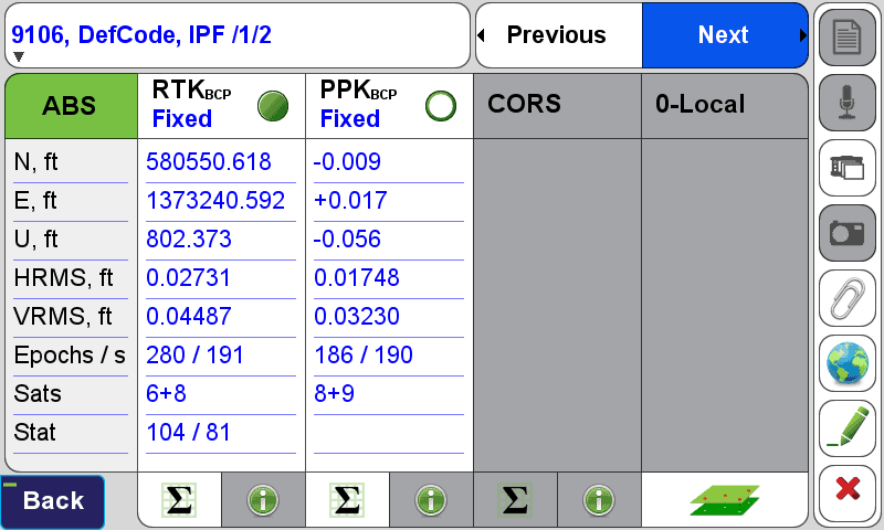
For the Javad, it was a base / rover RTK survey, radio link via mobile hotspots. Base in a nearby field??90% clear sky about a mile away. Each rover boundary location was measured with Javad??s ??boundary? survey profile which goes through at least a 3min verification process??please understand that some locations took up to 20 min. and some locations would not fix and had to post process for a fix.
For conventional, I used a 3? Trimble S7 robotic total station. Each traverse turn I measured two sets of rounds from poles/bipods. Side shots I measured one round letting the robot lock on the glass the whole time??typical medium accuracy (normal) woods traverse. The closure turned out fine: 14 turns – 5? angular & 1/33514.
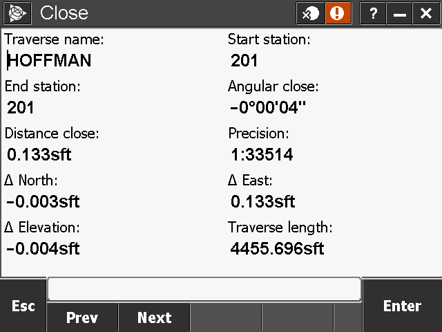
For adjustments, Javad LS does this thing called ??DPOS?. It processed the base to rover positions using the static data collected while on each boundary point. It then back in the office it automatically processes the base using CORS data and applies a shift to the base just like holding an OPUS position. (two separate base sessions 8 months apart agreed within 0.006????guess my pole is plumb!). You can view all the post processed coordinates next to the RTK derived coordinates and review the respective RMS/epochs/stats??and choose what you feel is the best coordinate for any given location. Last step in the LS was to scale the project to ground and output the data…both generally easy steps in the LS.
For conventional, I typically run a least squares adjustment through Trimble Business Center??but so far the Javad does not play well with TBC??or let??s just say…that is on my list of ??to-do??s?. In this case I went with a compass rule adjustment from Trimble Access??clean as a whistle??and it applies the adjustment to all the side shots??
Now I have one complete adjusted conventional boundary data set, and 19 common corners with the Javad Data set.
Combining the Data: In Carlson survey there is a coordinate transformation routine that lets you best fit two local coordinate data sets together in one least squares smack??great routine…it outputs residuals and lets you choose what you want to turn off or on in the equation. Below are the results of the least squares comparison of the conventional traverse to the RTK measurements. In all fairness…These are ALL the common points??all ??yes? for processing in the least squares comparison??no outliers that I??m leaving off here to make this thing look better than it is??this is the raw comparison of the two data sets as measured and described above??check it out for yourself.
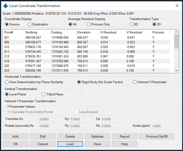
Results:
I thought this would be important for anyone to see who has the same questions I have…again…(Disclaimer!)…this is not a miracle machine…but it did WAY better than I expected…so I was compelled to share.
Also attached is an aerial showing the project location and the corners that posed a difficult RTK scenario. Lat/Long if you want to zoom in on the site on your own.
~ Timmy G.


Log in to reply.