
Activity Feed › Discussion Forums › Strictly Surveying › How would you make this close?
How would you make this close?
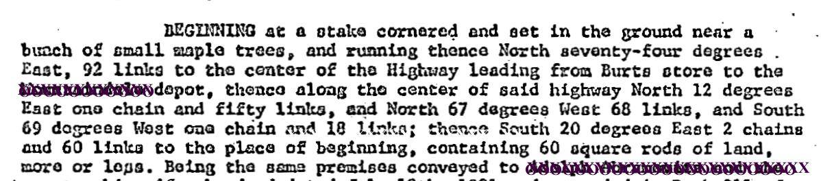
Posted by bill93 on November 30, 2020 at 10:45 pmI’m looking at an old deed, that probably copies an older description, that I could make close reasonably for the precision of the bearings and distances if I assume the last course was only 1 chain and 60 links instead of 2.60.
I really expected the SW course to go NW, and that reduces the closure but not nearly as well. I think it has been absorbed into a larger property, but it is one of a few parcels that don’t fit well together so I’m not even sure which order to try to fit them.
Is 1.60 chains the best solution, or did I miss something?
 MightyMoe replied 3 years, 4 months ago 14 Members · 20 Replies
- 20 Replies


I’d be inclined to check the previous deeds containing that description to see if there was a transcription error along the way. I’ve resolved a few bad closures that way.

I would rely upon boundary numbers that would match the 60 sq rods as the area.

Chat with the owner and the affected adjoiner to see if they remember how the lot was supposed to be shaped in the case of a missing course, or to see if their ideas of where the line should be are the same.

With GIS. That will close it EVERYTIME! ???? ????
In all seriousness, though, Do you have any ideas of the Surveyor’s identity? Sometimes, I’ve experienced several plats that had the same types of errors when drafting up their previous work, granted this is a deed, maybe the “scrivener” of the deed did similar mistakes and you can try to decipher their consistent inconsistencies. Just a thought.

Have you been in the field yet? Does the pob stake exist? Does the road exist? Tying into all occupation can present an obvious answer, that all other methods will not yield.
What we know for sure, is it has something wrong.
My standard go-to is field work to solve.
Without field work, what solution yields the correct acreage?
Enjoy,
N

Since it’s a described boundary what does the adjoining boundary describe? That could be the answer.

“Being the same premises conveyed to xxxxxxx”
My first instinct is to find that conveyance.
On a less technical note, my understanding is that this is largely one of your hobbies, and not so much a source of income. I am curious how you keep “business” coming in, finding new items of interest, etc.
-All thoughts my own, except my typos and when I am wrong.
As “antcrook” mentioned above it looks as if a course between deed calls 2 and 3 is missing. If you insert a course 1 chain long and parallel to the closing course the misclosure is 0.06 chains. This also yields an area of 63 square rods more or less.
 Posted by: @dmyhill
As a retiree, the forum is possibly the largest use of my time in these COVID days. It provides quite a bit of material for entertainment. I analyze plats and surveys of friends’ lots occasionally. Family lands offer uncertainties to ponder, also. No business to it.
This particular puzzle is related to a post here several weeks back asking for help in figuring out a deed. After I posted a reply, he sent me a bunch of old deeds to sort through and I’ve offered some non-expert ideas (labeled as such) on interpreting some of them. Fitting them together and putting them on Google Earth is more fun than jigsaw puzzles and TV, but they don’t fit well with the stone walls and roads seen (maybe one moved when paved? others abandoned), and I’m about at the ends of my ability to extract any more from the information I have, sitting hundreds of miles away.
.Great hobby. It is more fun when there is no budget!
-All thoughts my own, except my typos and when I am wrong.
@dmyhill I agree. Our Home Owner’s Association asked me to look into a parcel that was part of the property that the developer purchased from which our subdivision was made. It was a 28 foot wide by 600 feet long rectangle which connected the majority of the property to a side street. When the developer deeded all the “common area” to the Home Owner’s Association that strip of land was not part of the deed. I told them I couldn’t give a title opinion but would be glad to look into it. After a couple of days, a few hours of research, a couple of calls to surveyors and reading pages of deeds and plats. I determined (in my opinion) that the property still belonged to the developer and that they should contact him to either deed it to us or, perhaps sell it to adjoiners that could possibly use the property. I always enjoyed puzzles and having the time to look into it was fun.
Andy

I am aware of a subdivision where the developer had such a strip along one side (about 1300 feet), labeled it Lot One and never sold it, I suppose one of his heirs still owns it. There were two or three stubbed streets ending against that strip. I’m sure his goal was to prevent another developer from buying up adjoining land for a subdivision and having any streets there connect with streets in the first subdivision. Sort of a spite strip. It has worked out that way, too.
@holy-cow Yeah, there was a shopping center here that had a 1 foot strip along the right of way to prevent access except through the main road. That lasted a few years until the County condemned that strip for road widening. Access is allowed now.
Andy
@andy-bruner Back in the early 80s the 1ft strip set up by developers to block access to or connect a new road into an old road was declared illegal in Texas
@a-harris It may be here now. The original development was done in the 70s.
Might have been done through zoning regulations. The spite strips will violate many rules of associated with land division. Length vs width, minimum lot size. No need to pass a law to prevent them if the zoning rules do it. It would be interesting to see what Texas did.
Log in to reply.