
Activity Feed › Discussion Forums › Strictly Surveying › Interstate Highway Settling
Interstate Highway Settling
Posted by NotSoMuch on June 21, 2021 at 12:49 pmIn January 2019, you mentioned a project involving you monitoring the possible settling of an Interstate highway due to longwall mining beneath.
See:
Can you share the results? Did the highway indeed settle 3-5 feet?
Curious minds want to know.
bill-c replied 2 years, 10 months ago 4 Members · 8 Replies- 8 Replies

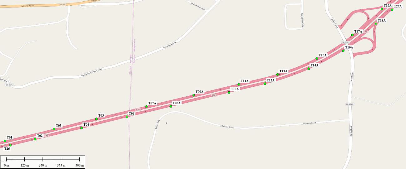
A map of the points…which were targets for mobile lidar placed along the outside shoulders on both sides…
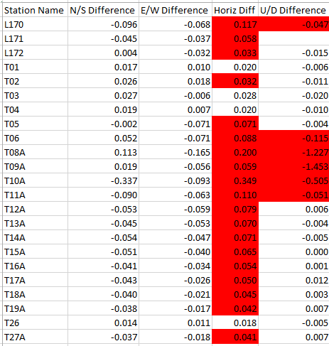
Here are the results from the final survey, in meters (versus the initial survey)
and a plot…
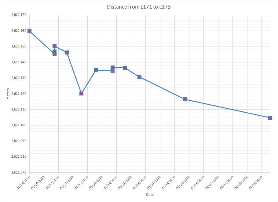
We had established control monuments that we thought were outside of the mining area, one east and one west, 2600 meters apart. It is interesting to note how the distance between them got shorter over time by more than 5 cm…
We occupied those with long session static GPS, and then ran a traverse between them for each of the 10 surveys, and I believe both of them moved, and probably were not actually outside the mined area. One of those was on a bridge, the other at a welcome center/rest area across the state line. The mining later continued across the state line (monitored by someone else) and under the rest area. I heard that they cut the rest area building in half to minimize damage before the mining started. Not sure how that worked out since we didn’t do that survey.
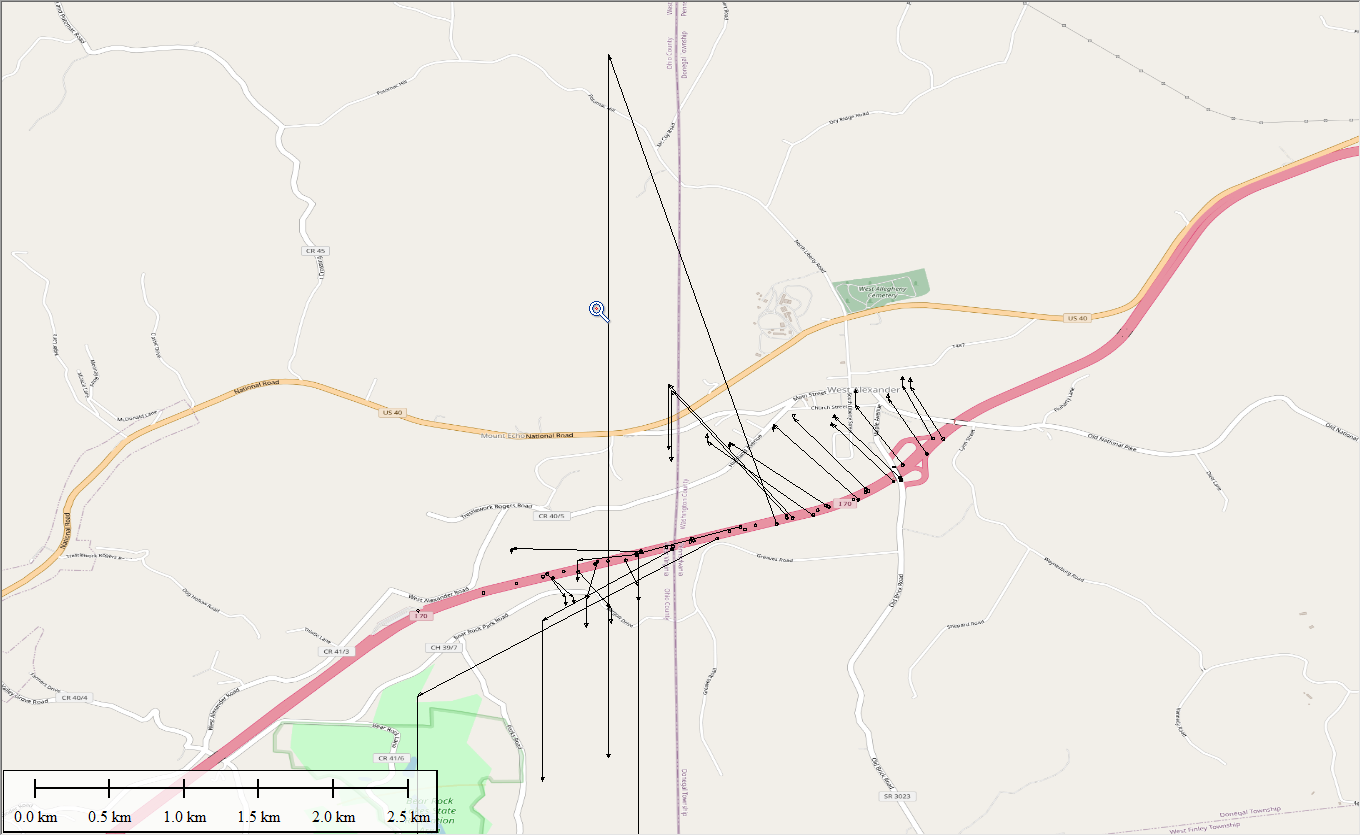
Here is one of the stations in the middle that showed the most movement…red is vertical, blue is horizontal movement
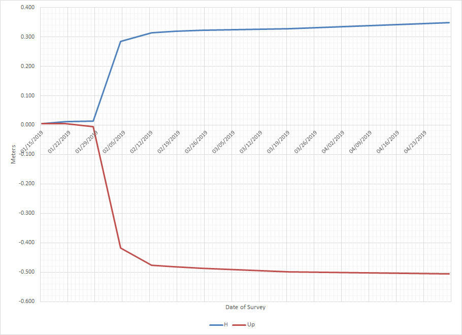
Some Pitt professors who were involved were more concerned about the horizontal movement than the vertical, said it was more damaging

@john-hamilton It boggles me that a mining company can go ahead with activities that cause surface topography changes (on land it doesn’t own) on the order of a meter horizontally and vertically. I’ve seen photos of cracked roadway pavement, and seen discussions about the potential to change the flows of streams, but I wonder about the effects on buried utilities. I’ve not seen any mention of that.
@bill-c As far as I know they had to pay for all repairs to the roadway and for the cost of the monitoring we did, as well as pre-mining studies, etc.
There is a lot of controversy nowadays about disturbing streams, sometimes resulting in no flow after mining. In the past that wasn’t such a big deal.
I guess they make economic decisions on the value of the coal versus letting it remain to protect surface infrastructure and buildings.
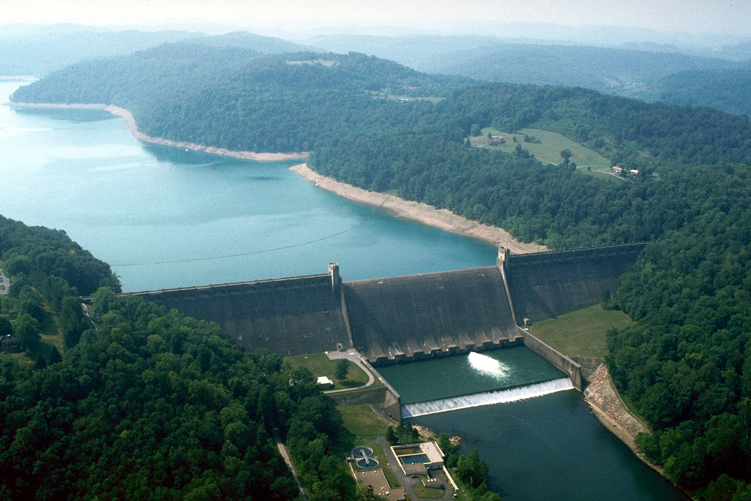
I am also doing monitoring 6 times a year on a large dam that is near long wall mining, but I don’t know how close the mining is to that, I am pretty sure they will not mine very close to or under the dam but they are nearby.
Here in PA my understanding is they can do whatever they want to get the coal, but they must pay for damages. My property was mined out a long time ago (underground room and pillar mining, not long wall), and they left the coal intact under an adjacent railroad.
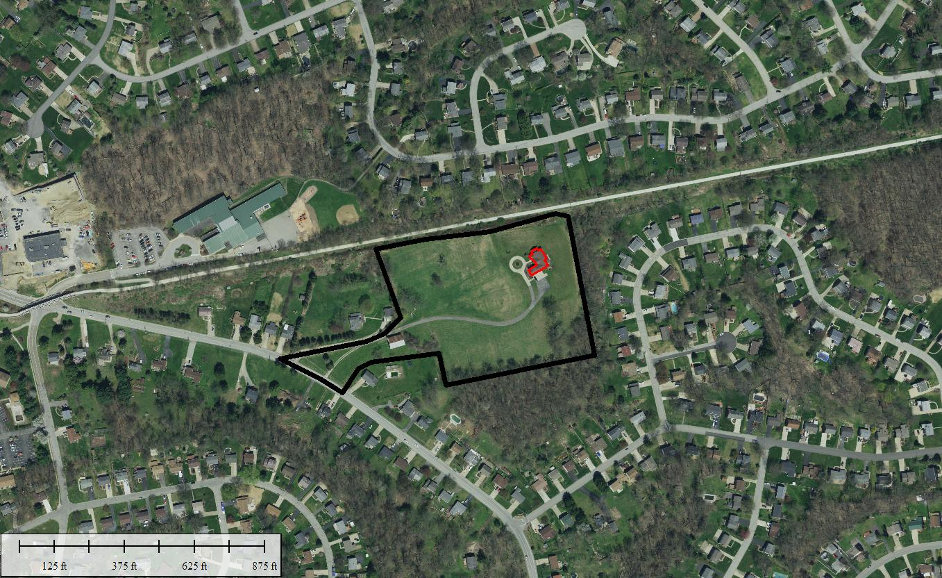
Here is what an aerial looks like today…my property is outlined in black, house in red. The line going through my property is the boundary between two mines.
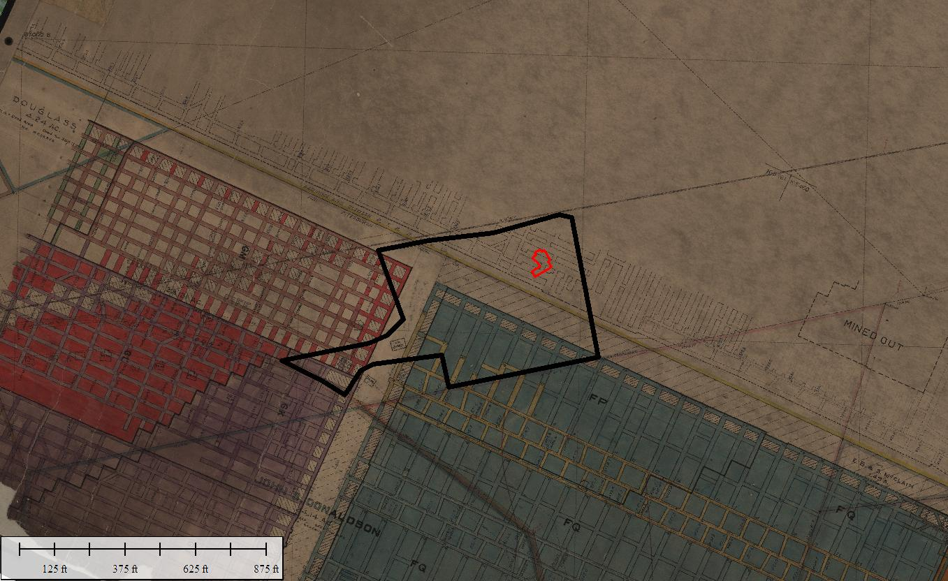
And here are the old mine maps…
The mines are 400 feet below the level of my house, which is at the top of a hill. I have not had any signs of subsidence.
@john-hamilton Given the long history and economic importance of coal in Pennsylvania, I figured there’s been legislation allowing the mining companies to cause subsidence, subject to their paying for damages ?? kind of a cousin to eminent domain.
Interesting about the mine near the dam. Sounds like the making for a disaster movie. ????
Also interesting about your property being over old mines. What is your house’s source of water? A drilled well? And if so, how deep? The new well that I had drilled last year hit decent water at 400-some feet, and we went down a total of 600 feet. I’m curious if there’s an aquifer above your old mines.

Who owns the mineral rights in PA?

Thanks for sharing the results.
As for mining near a dam – wow!
Fascinating topics and discussion – and way outside my wheelhouse!
Jeff D.The dam is pretty large, and old, built in the 30’s. As I said, I have no idea how close the mining is, but I would imagine they don’t come too close. No movement detected so far.
I have public water. But, my previous house, which was nearby on the same road had public water and also a well from before the public water came along. Wells here are typically shallow, a few tens of feet to maybe near a hundred. Most water supplies now come from surface sources.
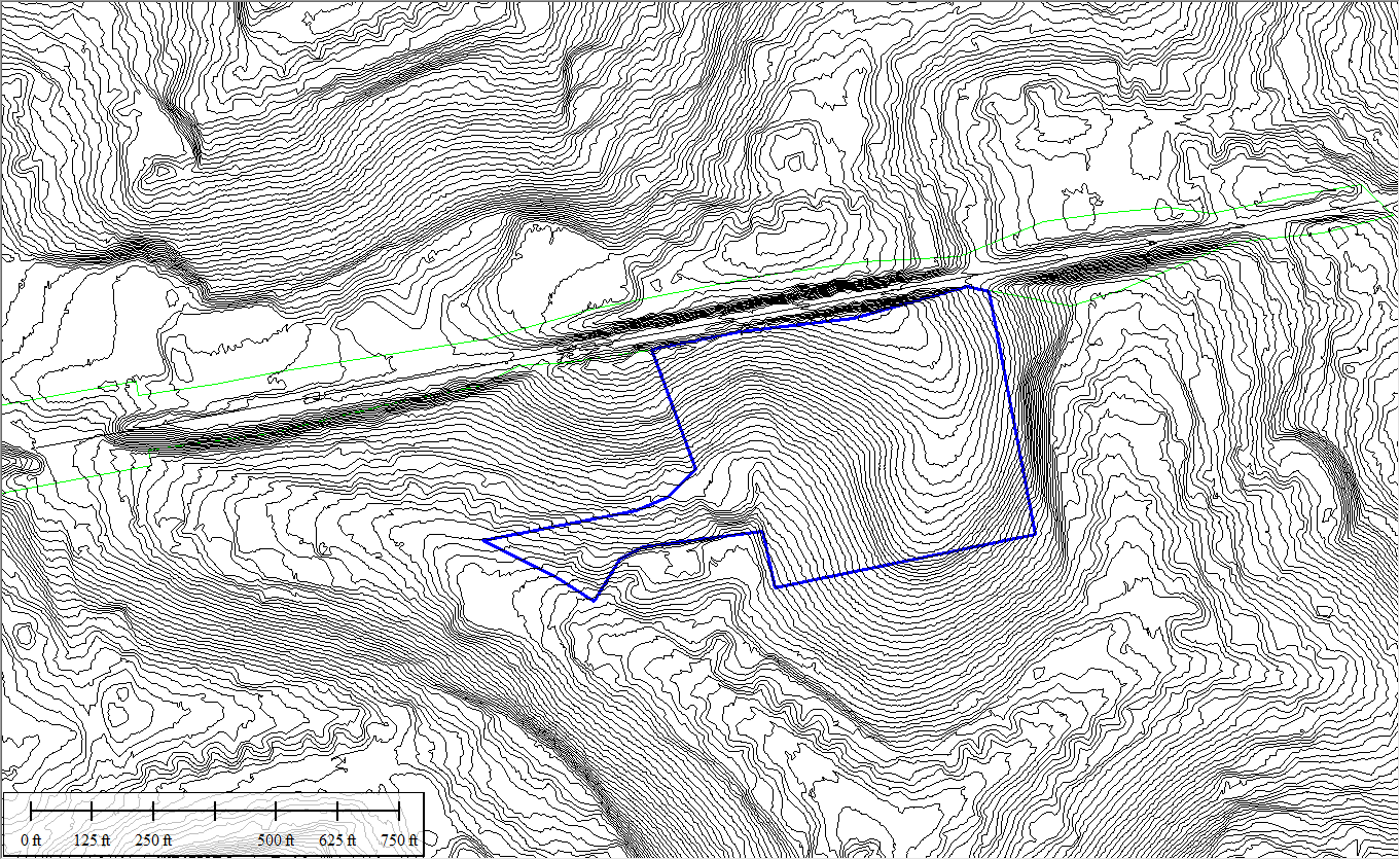
The mine floor beneath my property is at 830 feet, the high point is 1236 and the low point is 1148, so plenty of cover above the mine. But the area is very hilly, here is a plot of 2′ contours.
Mineral rights are privately owned. My research of my property deeds shows that only the Pittsburgh coal seam was bought (severed) in 1895. I can find no other transfer of mineral rights, so I believe that makes me the owner of the natural gas (and all other coal seams). There has been a lot of activity in the marcellus shale in the area, but the fact that I live in a somewhat densely populated suburb in an urban county mean that it is probably not likely to happen in the time I have left here. There are marcellus wells nearby, but in an adjacent more rural county. There is a LOT of opposition to fracking, especially in my county. They need a pretty big area for a drill pad, I think minimum of 5 acres, so new wells are usually only done now on large empty tracts, like the Pittsburgh airport. They tried to drill marcellus wells at the US Steel Edgar Thompson works, but that was cancelled due to opposition.
@john-hamilton Interesting stuff. I meant to mention in my reply yesterday that your property looks like a wonderful oasis amid the subdivisions.


Log in to reply.