
Activity Feed › Discussion Forums › Strictly Surveying › Monitoring a 200 year old dry laid stone wall for movement
Monitoring a 200 year old dry laid stone wall for movement
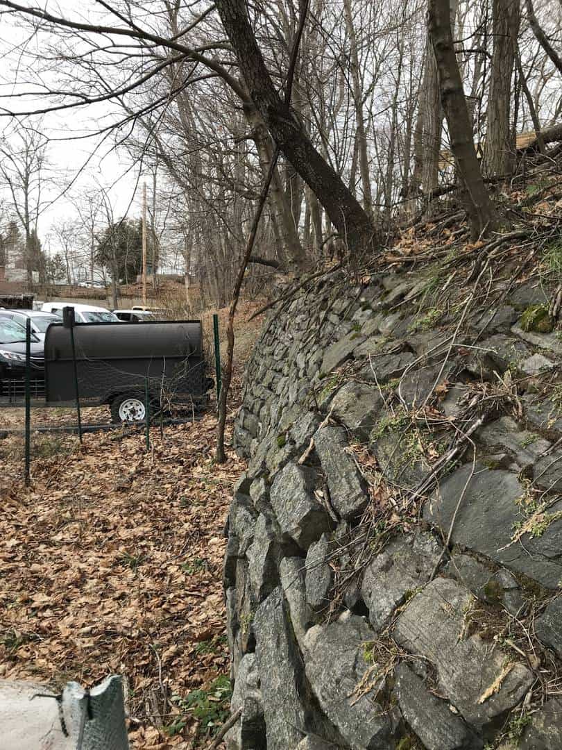
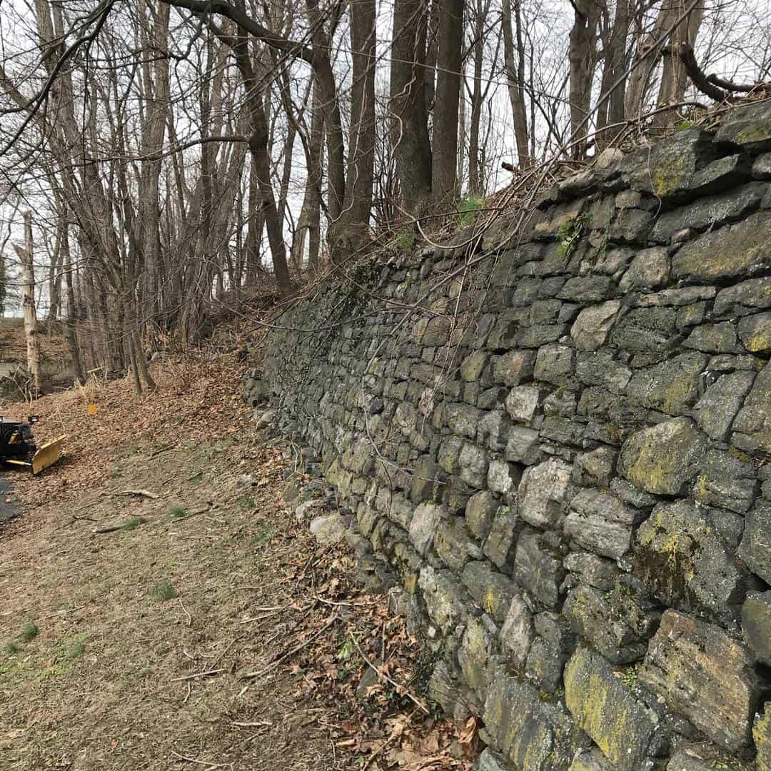
Posted by muncle56 on January 25, 2021 at 9:04 pmI’ve been tasked with monitoring this stone wall for movement (see photos). Wall is almost 200 years old and about 7′-8′ high. I’ve been told it’s probably 3′ thick at the bottom.
Anybody have any experience in this sort of thing? Any suggestions on how to go about it?
 paul-d replied 3 years, 2 months ago 16 Members · 16 Replies
- 16 Replies


That looks like a job for a scanner, since the wall might not move as a unit and you don’t know how many reference points you need. You might need to set some nails in there for future horiz/vertical alignment of the images.
.
Start with a robust control baseline/network so you can prove your control is not moving. Then move to collecting data on the wall. A baseline with 3 points on line between the 2 end points and then a couple of angle checks for example. Steeples or antenna towers work well. Targets affixed or otherwise physically a part of the wall allow for the repeated measurements. Do you measure every stone with a scanner or do you identify individual points of interest? The more you can keep everything the same (equipment, procedures, observation points) the better.

Bill and Lurker have some great ideas. I??m curious as to the reason for this? What??s the time frame? Be sure to budget accordingly ???ý

Scan it. Software will show differences between scans.

That’s a lot of potentially moving parts. I know very little about scanning, but that would seem to be the way to go. Otherwise, you might set a hundred check points per a certain length of the wall. That’s a huge amount of data to compare manually and one heck of a lot of shots from a very solid set up using the same equipment every time.

Just based on your first photo, I would say YES, it is moving.
I know this doesn’t help with your question. It really depends on what equipment you have available.

I don’t think you will find the rate that it is moving at to be constant but rather a function of the degree of water saturation of the retained soils as the weight bears down on the wall. In other words when dry there’s very little to no movement but following a prolonged rain event the movement accelerates with the increased load and soil lubrication.
Willy
The scope needs more definition.
The best approach is to measure it with the equipment and procedures you are comfortable with and report accordingly. Keep it simple and repeatable and do not report anything beyond what you can measure.
Doubt there is enough work there to learn too many new tricks.

If you don’t have access to a scanner; I would place targets, at strategic locations and measure those at standard intervals from solid control. Report your findings in a spread sheet, created in excel. What they do with the data, is up to them.
I hope everyone has a great day; I know I will!
A lot depends on the type and magnitude of movement you are trying to observe. A scanner may be the ticket, or it may be massive overkill.
Once you answer those questions do two things.
1. Screw it up exactly the same way every time you observe.
2. Report it in a format meaningful to the client. Most clients have no use for a coordinate table. They need to quantify movement of a structure relative to a feature.
Hope that helps, Tom

What is purpose of monitoring?
has 200yo wall suddenly moved?
does client have structural engineer on board.

Done this exact thing on a newly built overpass that was suspected to be bulging. And yes- it was scanned (this was in 2003!). Every week for 2 months.
We determined it was indeed moving and the whole thing got rebuilt.
Also did movement monitoring on the governor??s mansion after it was nearly burned down about 10 years ago (all kinds of stories about that one). But it was way fewer data points, and we just used targets fastened to different parts of the building, shot conventionally.

As others have said, whatever way you do it you MUST have immovable reference points somewhere.
Depending upon how long between surveys and how much movement is expected, if scanning you might need to sweep off all the leaf clutter which collects between the stones – if the movement is small or intermittent it does make a difference. Stones can “roll” in the wall (see near the trees growing out of it) and leaf clutter can disguise that.
In dry weather the wall might move back as the ground behind dries out – I’ve had that happen, especially where the top of the wall is leaning back as this one does: then the upper stones might settle rather than move in x,y.
If you put targets on the wall, make sure they can’t come off – small paint dots might well do. On the size of the wall shown it isn’t going to take long to observe individual points – record in co-ordinate mode, drop into a spreadsheet and the office work is minutes. “Contouring” the face in x,z with y values as the contours will show up what is happening very quickly
What is the total length involved and what is the potential loss if the wall failed completely?

Sounds like maybe there is nearby construction that requires proof that adjacent infrastructure is not damaged. Around here our walls move all by themselves, stones rolling off the top as they heave with the winter frost and spring thaws.
Good luck with your project.
T.W.

I worked on something similar but it was for a coastal gun istallation from WWI. They knew it was moving, but didn’t know where, by how much, or if reinforcing that had been installed had stopped the movement. We had a structural engineer identify areas of concern for different movement, installed prisims on the structure where we needed, then measured the points twice a week for a a month to get the average. We then monitored the locations every six months and reported the deviations from the original measurements. Our control was in bedrock, so was quite stable.
If I had access to a scanner at the time it would have been a superior method.
Log in to reply.