
Activity Feed › Discussion Forums › Strictly Surveying › NAD27, is it US survey feet or International feet?
NAD27, is it US survey feet or International feet?
Posted by half-bubble on April 29, 2022 at 5:57 pmI have an add-on package for Bricscad that does coordinate systems and projections. It is using EPSG 30248 for Washington State North Zone and EPSG 30249 for WA South Zone. Those seem to be specified as International Feet, and I am wondering, is that really so? If I use these to convert some old NAD27 section breakdowns to NAD83/2010 they wind up out in left field because of the large coordinate numbers and the difference between the kinds of feet.
rover83 replied 1 year, 9 months ago 21 Members · 33 Replies- 33 Replies

Isn’t that state-specific, just like with NAD88. How did Washington state implement their version of NAD27 State Plane Coordinates?

It is state specific. In Oregon NAD27 is US Feet, NAD83 is Int’l Feet. Washington has been US feet for both, at least until recently.

I never thought of it before but what feet are our elevations expressed in? Do these states only use international feet for horizontal and US feet for vertical?

From the NGS FAQ page (toward the bottom):
“For most of the years surveying has been undertaken in the United States, surveyors have used the U.S. Survey Foot…In fact, NGS originally computed and published SPCs in U.S. Survey Feet for many years when the reference system was the North American Datum of 1927 (NAD 27). And the conversion formulas (latitude/longitude to SPCs) were developed to produce U.S. Survey Foot values. In fact, NGS never published NAD 27 SPCs in meters.“
I suppose one could convert if they really wanted to.
“…people will come to love their oppression, to adore the technologies that undo their capacities to think.” -Neil Postman Posted by: @lurker
US feet for vertical?
NGS works in meters. The DSdata.pdf linked on all NGS data sheets contains this footnote about the orthometric heights in feet:
Heights in meters are converted to U.S. Survey Feet by using the conversion factor H(USSF) = H(m) x (39.37/12.00). Height in feet is rounded to 1 less decimal place than the corresponding height in meters.
It doesn’t really matter because the difference is 0.02 ft in 10,000.
. Posted by: @bill93
It doesn’t really matter because the difference is 0.02 ft in 10,000.
You’re off on a tangent about verticals. It actually does matter quite a bit if you are trusting a conversion tool to get you from NAD27 to NAD83. The state plane coordinate values are large enough (hundreds of thousands and millions) that the conversion multiplier will put you more and more somewhere else. I don’t trust the tools unless I can confirm their results. This one is wrong. Vendor points to EPSG definition.
- Posted by: @lurker
I never thought of it before but what feet are our elevations expressed in? Do these states only use international feet for horizontal and US feet for vertical?
Questions like these are why the NGS mostly uses meters.
For most elevations the difference between US feet and Int’l feet is trivial. For example, 1000meters height would be 3280.833 US Feet, and 3280.840 Int’l Feet. That’s not enough difference to break the surface tension.
I was responding to a question about verticals. Nothing I said was about horizontal. Of course it matters when you have SPC in the millions.
.
The international foot was defined in 1959.

We’ve seen a couple near FUBARs with US vs. International feet in the horizontal plane. Since the early 1990s a lot of work in this area has been done on a county-wide low distortion projection coordinate system. N and E values are international feet. In one case, new cells for the landfill were designed by a company in Idaho, using US Survey feet. They sent the finish grade terrain models for these cells to the landfill for the (machine control) contactor. The difference between international feet and US Survey Feet is in the neighborhood of 2 feet per 1 million feet. At the landfill the northings are around 360,000′ and eastings are around 3,300,000′. So when the files were loaded into controllers with the coord system correctly setup in international feet, the design was off by about 0.7′ in northing and 6.6′ in easting. Fortunately the landfill contracts with a top notch local surveyor for their quality control and he knew immediately, given the 2 ft per million ft difference in the two measurement units, what had gone wrong. In another situation a local office of a big western multi-state engineering firm was given cad files of existing-ground topo, survey control network and Civil 3D existing-ground terrain model for a road corridor design. They gave the job to a green EIT to design. From their office in Washington State (a US Survey feet state) he got a Civil 3D design template that was in US Survey feet and imported all of the existing topo and terrain model. He designed the road and sent the Civil 3D files back. Fortunately the problem was discovered when the finish grade XML was brought into the original, international feet, cad topo file. The design was a very noticeable 6’+/- in easting and about a foot in northing off. Had the EIT let the office surveyors set up the initial project this would not have happened. But he learned an important lesson which I imagine he was very cognizant of at the next place he found a job at. This work ain’t for button pushers.


A county wide LDP with coordinates in 3,000,000 ft.? That must be a really, really big county.
false northing/easting at the origin
It??s 3,055 sq. miles, but like Mark said it??s false N and E.
Yeah, I didn’t think any of the county was hundreds of miles out in the Pacific, but that begs the question why make the numbers so large? I’m assuming they used 1,000,000 meters for the false easting on the origin point and I’m further assuming the central meridian is located close to the center of the county east-west. I’m just curious, most LDP’s I’ve ever set up or used tried to keep the numbers small since the whole idea is you don’t want to wander much outside of the projection center.

@mark-mayer
That is similar to the numbers I’m used to.
Maybe some of the Zones got large numbers to keep from getting the zones confused?
80,000m makes sense for a false easting.
- Posted by: @mightymoe
but that begs the question why make the numbers so large?
This LDP was conceived in 1988 and realized with the first published data set in 1992. Maybe other LDPs created 30+ years ago used the same coordinate scheme? I dunno. Or care. The mastermind of this multi-county system, Bill Kauffman, died a few years ago and I never questioned him about why the big numbers. It has stood the test of time for over a generation. You can page through the 212 page August 1992 initial data set to look for answers. 10 more data sets were published in the next 6 years as the network expanded to over 700 marks in a three county area… the majority of them on PLSS corners. Kaufmann was a rare visionary in the dawn of GPS… his work was beyond compare and his methods extremally rigorous. Knowing from decades of experience that state plane coords always needed rescaling at our base elevation of 3600′ + he created a system that worked for most of the private lands in this county. I’ve used this system hundreds upon hundreds of times in the last 30 years with both static and RTK GPS (a system not even imaginable in 1988) and have not found a significant error (like 0.10′) of any sort. For some reason the large eastings haven’t bothered me. That bell can’t be un-rung, although the state Johnny-come-lately DOT developed their own LDP coordinate system for this area 20 years later with slimmer coordinates when LDPs became a fad.
Looks like I broke this thread with the above post, maybe this one with different hyperlinks will fix it?
Posted by: @mightymoebut that begs the question why make the numbers so large?
This LDP was conceived in 1988 and realized with the first published data set in 1992. Maybe other LDPs created 30+ years ago used the same coordinate scheme? I dunno. Or care. The mastermind of this multi-county system, Bill Kauffman, died a few years ago and I never questioned him about why the big numbers. It has stood the test of time for over a generation. You can page through the 212 page August 1992 initial data set to look for answers:
10 more data sets were published in the next 6 years as the network expanded to over 700 marks in a three county area… the majority of them on PLSS corners. Kaufmann was a rare visionary in the dawn of GPS… his work was beyond compare and his methods extremally rigorous. Knowing from decades of experience that state plane coords always needed rescaling at our base elevation of 3600′ + he created a system that worked for most of the private lands in this county. I’ve used this system hundreds upon hundreds of times in the last 30 years with both static and RTK GPS (a system not even imaginable in 1988) and have not found a significant error (like 0.10′) of any sort. For some reason the large eastings haven’t bothered me. That bell can’t be un-rung, although the state Johnny-come-lately DOT developed their own LPD coordinate system for this area 20 years later with slimmer coordinates when LDPs became a fad:
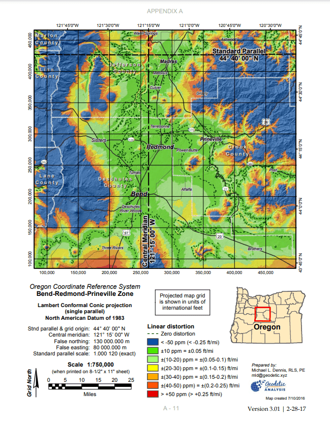
https://www.oregon.gov/odot/ETA/OCRS/OCRS-Bend-Redmond-Prineville-LCC.pdf

All I had is that I don’t consider the coordinates of the subject LPD large. I answered many a call when I supported our 14 LDPs where the first thing mentioned was your LDP coordinates are in the ocean. It made for short calls as I immediately new they had chosen the wrong system. Our largest easting was in the 24 millions. A quote from our handbook: “It is strongly recommended that the coordinate values everywhere in the design area be distinct from other coordinate system values for that area (such as State Plane or UTM) in order to reduce the risk of confusing the LDP with other systems.”

Log in to reply.