
New help understanding old terms
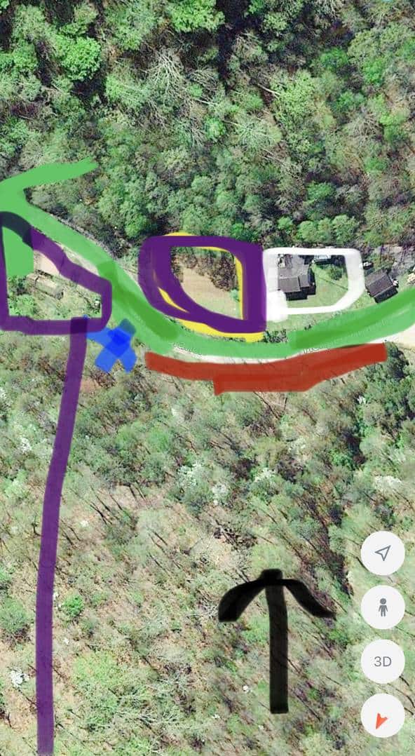
I??m new to surveying and I don??t have a license . I am located in rural Kentucky and I had a friend ask me into look into this and I??ve studied it for weeks and just can??t quite understand the terminology but I??m not as experienced nor as old to maybe have seen or heard these terms used. I??ve figured out most of the property line but where it ends. It goes like this, at the ridge with John Henry line running down hill with said line to jones Branch; thence up jones Branch to a planted stone on left side of the Branch (I could not find a planted stone); thence a straight line across bottom and Branch with the lines of John Henry to a maple at pailing fence and bill smith line; thence with said line to Tom Johnson line; thence with said line to end of cliff; thence on off to jones Branch; thence running down the center to same beginning. John Henry owns the purple tracts and my friend and John Henry is trying to find the property line. The blue x has a maple at a old fence on the line of the purple John Henry and white bill smith line is also a old wooden fence and the Tom Johnson line is somewhere right of the white line, possibly the edge of the creek in between the white line and the green which is the road. Green arrow pointing up is going up the road. The black arrow is going down the hill and the red is the cliff which is on the left side of jones Branch. I couldn??t figure out when it meant end of cliff meaning end of cliff meaning looking at the road or end of cliff going up the road way (green arrow) almost to the maple. Any understanding of this?


Log in to reply.