
Activity Feed › Discussion Forums › Strictly Surveying › Original and Undisturbed
Original and Undisturbed
Posted by RADAR on July 18, 2021 at 6:50 pmI’m retracing a lot in a 1978 Short Plat (a subdivision with 4 or less lots), lot 2.
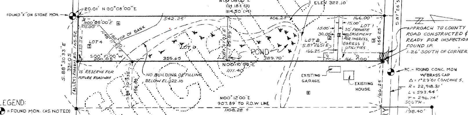
First problem I run into; the lot doesn’t close. (see screen shot)
Problem B; I found an original, and undisturbed iron pipe, with the origin cap, from the original surveyor, 2.004354298756′ south of the calculated position. (sorry… 12 decimal places is there for comedic effect)
So, you’ll also see, in the screen shot; a big part of this property is swampland. Is this going to play a part in what I should hold?
The original surveyor has a questionable reputation; it’s hit and miss, when retracing his surveys.
I’ve been doing this (surveyoring) for 46 years, so I’m 99% positive I haven’t left any stones unturned. But there’s always that 1% chance…
What would you do? What would you hold?
Thanks in advance for your sage advice.
Dougie
rj-schneider replied 2 years, 9 months ago 12 Members · 26 Replies- 26 Replies


bearing on W pl of lot 2 doesn’t help any.

- Intended to be a 2′ witness corner?

I’d like to see the entire plat before pontificating. The snippet is confusing concerning the meaning of the monument symbolization. Did he set rebar at the new lot corners, for example?
OTOH I’ll fire off a few thoughts off the cuff. If the Fd. rebar is referenced on the plat, then barring a junior/senior rights situation etc., it *is* the corner and you should honor it. I don’t see how the swamp delineation on the plat or in the field presently would affect your survey. Also your “Lot 2 doesn’t close” statement is vague, is it misclosing by tens of feet, a foot or a few tenths? Depending on the magnitude of the misclosure and possibly a paucity of missing monuments you may have to resurvey the entire plat to localize the misclosure error (transposed numerals?) for correction or perform some sort of proportionate adjustment to establish Lot 2’s corners.
That the original surveyor has a questionable reputation; good to know but not something to complain about especially to you client. His survey is what it is; be grateful for a badly done survey of record compared to no record at all.

That’s what I was thinking as well.
I was following a survey last year. There were 25 or so monuments to recover, one was out of place and was 4′ south of the corner, the other recovered monuments fit within .2′. This was a survey large acreage tracts so .2′ wasn’t any concern. The 4′ off monument would have fallen in an irrigation ditch if the corner was monumented. On my plat I simply showed it as a found WC. even though that wasn’t record, simple deduction can fix issues sometimes.
@mightymoe Better be accurately described in the record map.
I’d never set a witness monument 2′ from the true corner because it causes confusion. If the corner is literally on top of a concrete wall I’ll set a L&T on the top of the wall. If the corner is in a dismal swamp I’ll set a witness corner 20′ away on line. If the (large) parcel(s) are adjacent to a big active accretion/reliction river I’ll set a line witness monument 150′ away and find 10 years later my monument is only feet from being submerged and perpetuate it with a new line monument another 150′ back and try to make in agreement with the boundary line continuation on the other side of the river.
Setting a permanent monument um, somewhat close to the true corner as a witness is an anathema and is bad practice. There are exceptions of course, like street line monuments in subdivisions on 5′ setbacks so the utility guys don’t rip them out; they’re merely line witness monuments for the true corner where the side lot line intersects the R/W line. Of course the contrary may be shown so stay on your toes.
@mightymoe Yup, it’s an easy game with 90% of found monumentation being within a few tenths of record and a few poopers are off by feet. Still, I’d hold the outliers if a record stable monument was in place; it’s a record of intent unless a blunder can be proven.
 Posted by: @mike-marks
The other factor is reliance by the land owners. If nobody noticed the monument or did anything in reference to it, then why not correct it?
.
Wait a minute. North is to the right. Who ever came up with that stupid idea? Thought that only happened on DOT plans.
- Posted by: @holy-cow
Wait a minute. North is to the right. Who ever came up with that stupid idea? Thought that only happened on DOT plans.

ugh .. that changes things. South pl on lot 2 then. Thanks cow
@bill93 Exactly. Owners in repose deserve an equitable solution and it may be a found record section corner monument hundreds of feet different when they’ve plowed between the tree on the road and the cliff on the other end for 100 years. Kinda hard to survey that out and maybe say yep, occupation holds over monumentation or be a dick and demand quitclaim deeds with an ROS which straightens things out. Not gonna happen because of costs.
Everything needs to be considered, this monument was near a strong angle point in a fence, the fence jumped across the ditch with a little canted section tying long straight fence line sections together, the P.I. of the long fence sections lands in the flowing ditch and the cap sits 4′ from the P.I. on the bank of the ditch, it was an easy conclusion to reach. There was no point in monumenting the actual corner. So calling the capped monument a 4′ W.C. was the best solution. Sometimes you need to reach a decision and move on.

Perfect illustration of why North should always be up. Even surveyors get confused.
Why do some surveyors have such an aversion to plotting in portrait?
Because making that decision requires all interested parties to buy in. It’s never a decision that a surveyor or one land owner can make without potentially causing a future conflict.
An original survey is an original survey, whether anyone notices or not. The boundaries can of course move… but not without either approval of all affected parties or the blessing of a judge.
How can you be certain that no one noticed without the legal requirements of notice being met?

Just out of curiosity, did you find any reason why the bearings on the North South lines graduate 00-02-00 degrees as you move east to west? It just seems odd. I’m curious what he was trying to accomplish by doing this.

The difference in the bearings is because of the original parcel; it’s fairly common around these parts.
No, the SW corner isn’t a witness corner; it falls on a slope, down to the pond. I don’t think anyone has seen it since the Jack-Leg surveyor set it.
I’m going to hold the pipe, and use the direction, out into the pond, to show where the SE corner should be. Because that is what I believe was the intention of the original plat. I’m not going to set anything out in the water.
Prove me wrong…
I hope everyone has a great day; I know I will!@dougie
So it wasn’t a witness corner, but now it will be a witness corner? ????
- Posted by: @mightymoe
but now it will be a witness corner?

Nope; original, undisturbed monuments hold, no matter what the math says…
At least that’s what case law says
I hope everyone has a great day; I know I will! @dougie
Oh I mis-understood your post, you are accepting the monument as an original,,,,,,so what’s the tie to the “point where it’s supposed to be” about? Why show that, the point where it’s supposed to be would be the original undisturbed monument.

“…the point where it’s supposed to be would be the original undisturbed monument.”
That is a profound observation!

Log in to reply.