
Activity Feed › Discussion Forums › Strictly Surveying › Plat Narrative
Plat Narrative
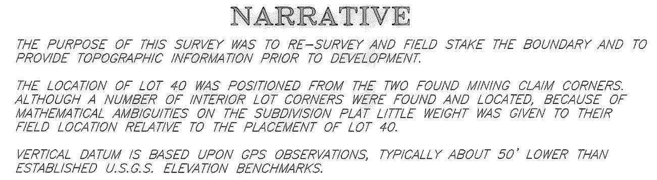
Posted by loyal on October 14, 2021 at 3:08 amI came across this a couple of days ago, I particularly liked the “vertical datum” note (the Geoid height in this area runs around -15.5 meters).
 dave-karoly replied 2 years, 6 months ago 14 Members · 24 Replies
- 24 Replies


Wow. Just …. wow.

Well, if you had stayed retired you would have avoided this nitwittery.

@mark-mayer Ya can’t make this stuff up! Actually I HAVE seen worse…much worse.
On the upside, it tells me more about his survey, than the author probably intended.
@loyal And don’t forget to to include the difference between NAVD88 and the U.S.G.S. elevations being in NGVD29 (assuming that they looked at spot elevations on a USGS quad sheet for the “U.S.G.S. elevations”).
@gene-kooper Some of the U.S.G.S elevations (including both contours & Bench Marks) predate NGVD29 by quite a bit (1901 Topographic Map) and BMs which were stamped with the elevation and SLAK (Salt Lake Datum)
@loyal I think you are being too generous with the extent of his research. With that narrative, it is more likely that he came across a 1950s or 1960s vintage USGS topo quad rolled up and stashed in a corner of his office.
 Posted by: @gene-kooper
Well, if you had stayed retired you would have avoided this nitwittery.
I love this word. I can’t say as I have ever heard it before.
ps – for some reason it seems a particularly comfortable fit in a discussion of land surveying… 😉

That’s incredible. Like you said, this is actually very informative Metadata.

I’ve seen “Datum: GPS” quite a bit.
Concerning that note, it would seem to indicate that no geoid separations were applied and heights are ellipsoidal…which is something else I have seen a few times on topographic surveys. In this area the difference is ~70 USFt.
“…people will come to love their oppression, to adore the technologies that undo their capacities to think.” -Neil Postman
The GPS thingy I’m guessing isn’t the real problem.
He found the original monuments and rejected them? “because of math” That’s a quote!!!!

He found the original monuments and rejected them? “because of math” That’s a quote!!!!
Yeah, I actually find that more amusing than the GPS bit. Hopefully someone came along and got this guy up to speed pretty quick, changed careers, etc.

If the math is ambiguous shouldn’t the existing monuments hold more weight? And we don’t know if he’s on grid or ground. We do know he’s in GPS nirvana.

The scary part is, the narrative worked. We all know exactly how he wrecked the boundary.
If this guy was in my town we’d have to talk..
- Posted by: @norm
And we don’t know if he’s on grid or ground.
And who knows what that “grid” could be and what projection it was derived from. I once came across an azimuthal projection…
“…people will come to love their oppression, to adore the technologies that undo their capacities to think.” -Neil Postman As for what “grid” he used, I think folks are overthinking this again. I have a sneaky suspicion that he [ab]used the localization feature of his GPS black box with three points that are only 200 feet apart and in a straight line.
The “Subdivision(s)” in question were surveyed by a father & son team in 1964 & 1965 (both were Registered Engineers & Land Surveyors), and have been a notoriously festering boil on the local cadastral fabric ever since (particularly the exterior boundaries). Within the subdivision itself, little evidence of the original 2×2 wood hubs remain, and even fewer have been recovered over the years, and there is a hodgepodge of unmarked ReBars and various “subsequent” attempts to set property corners. In any case, it is a mess. I am only concerned with the exterior boundaries, and that’s more than enough headache for me.
 Posted by: @mightymoe
The GPS thingy I’m guessing isn’t the real problem.
He found the original monuments and rejected them? “because of math” That’s a quote!!!!
@mightymoe How I wish this were isolated to just your neck of the woods.
Willy
Is this from Park County by chance???? ????
I’m lucky, I don’t have this junk here much, a little of it, but it’s minor.
I do have a similar subdivision to what Loyal is describing and I have a big X drawn through it. There will be no one from my office working in that subdivision. Even if they do what I suggested years ago and form an HOA to get it “fixed” I will not be part of it. However, about 5 years ago I did do what Loyal sounds like he’s doing and surveyed the north and east boundaries of it for a good client.
If Loyal steps across the boundary line and enters into the interior mess that’s probably there,,,,,,I will be so disappointed with him,,,,,,,,STAY OUT OF THERE LOYAL!!!!!
Log in to reply.