
Activity Feed › Discussion Forums › Strictly Surveying › Subsidence
Subsidence
Posted by rj-schneider on January 15, 2022 at 4:12 amFound a good subsidence photo at a recent job. Structure likely from the early ’70s.
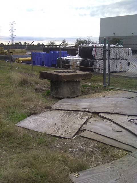
Just now looking at this, and the plywood, wondering if they didn’t raise and collar this to keep it out of flood waters. ????
Anyhow, hoping this was subsidence, since I titled the post subsidence.
spmpls replied 2 years, 3 months ago 9 Members · 19 Replies- 19 Replies


I would think subsidence would occur mostly at lower depths than the structure, so the top would still be near the surface level. That’s an argument for a collar.
.
Thanks, Bill. Made me do some looking. This is the area.
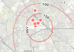

Dang. I’ve been in that area. But, about 35 years ago. Spent quite a bit of time in Jersey Village and drove all around.

@rj-schneider Looking at the bottom of the “cap” around the manhole shows the roughness one would see if only the sides were formed up for the concrete pour. Something changed, subsidence or rise of the structure or both. It also isn’t recent as evidenced by the parking slab and fence nearby. That much subsidence would certainly affected them unevenly.
Another possibility is the cap was poured in place and the area was graded to the levels we see today with the slab &c. and the soil near the manhole eventually leveled and grass grew.

This site might also be of interest:
- Posted by: @jacavell
It also isn’t recent as evidenced by the parking slab and fence nearby. That much subsidence would certainly affected them unevenly.
If it helps any, not this commercial site, but the commercial site to the North, I was on the crew when the building envelope was staked back in ’13. I can’t picture this site in context, if I remember correctly this stretch of road was a lot of vacant property back then.

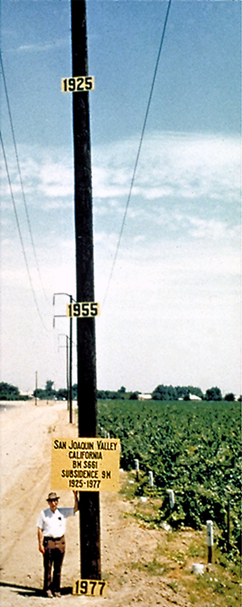
Subsidence? That is just a little ground surface settlement. This is subsidence. Almost 30′ of it between 1925 and 1977.
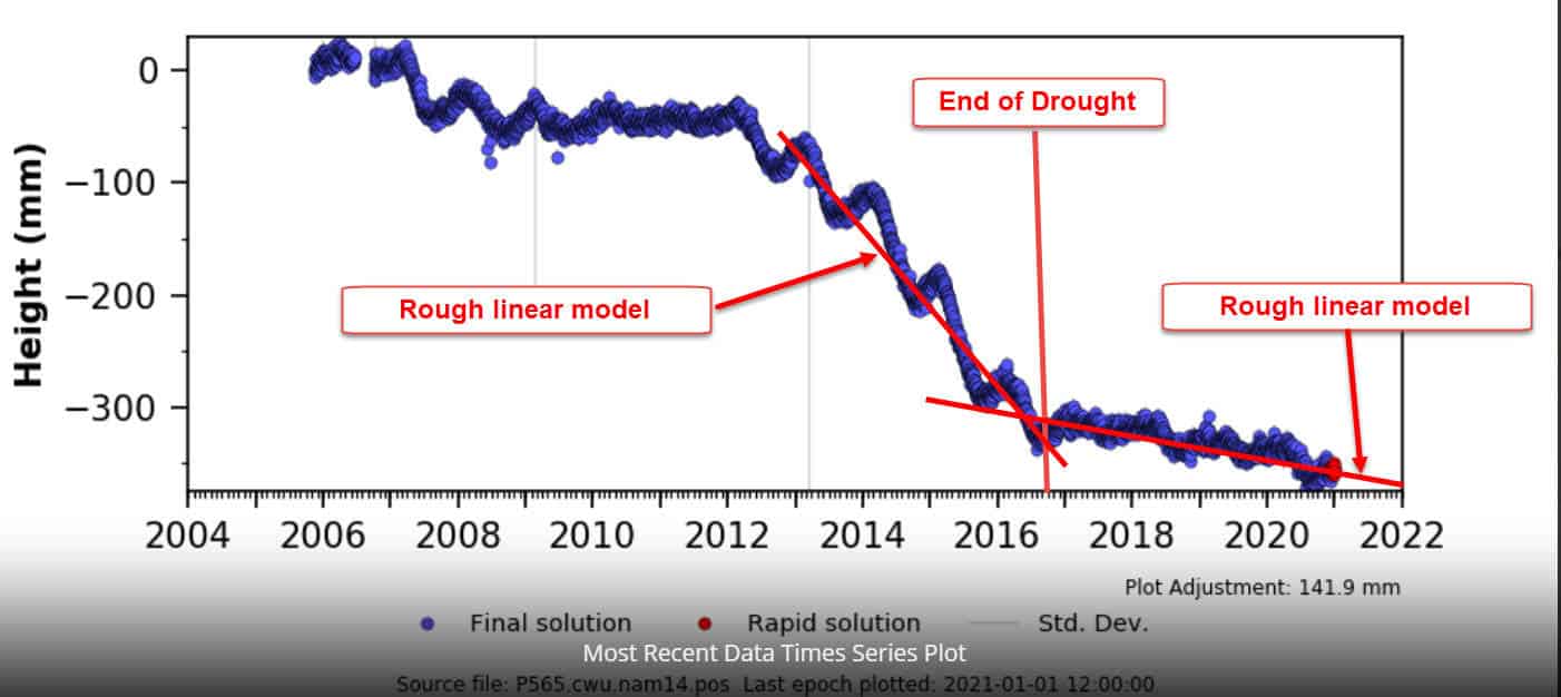
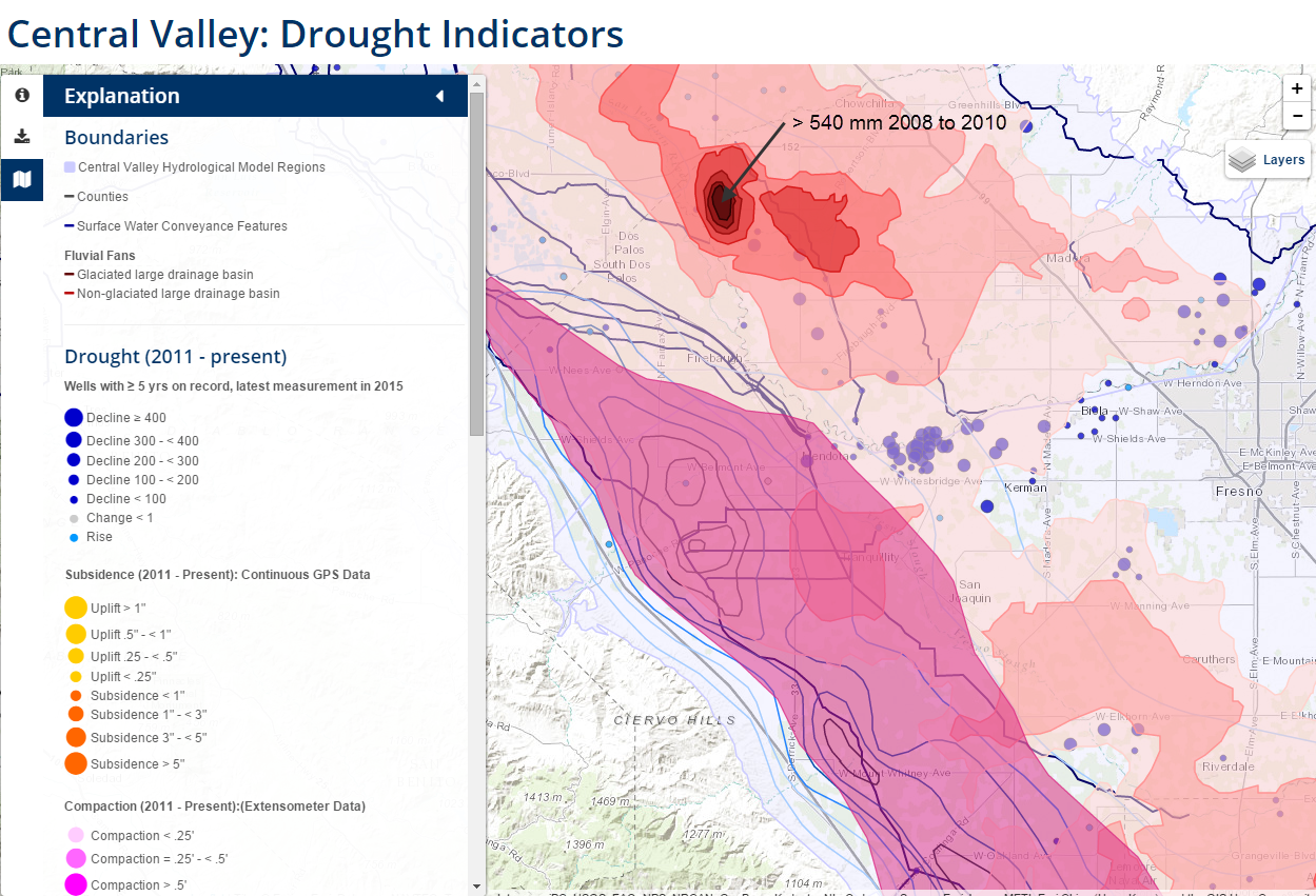
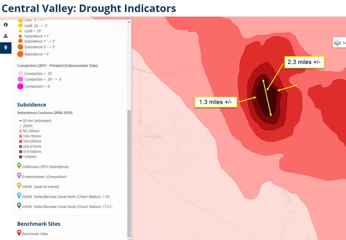
We had an area in California referred to as the “El Nido Bowl” subside over 2′ from January 2008 to January 2010, which was before our drought period from 2011-2015.
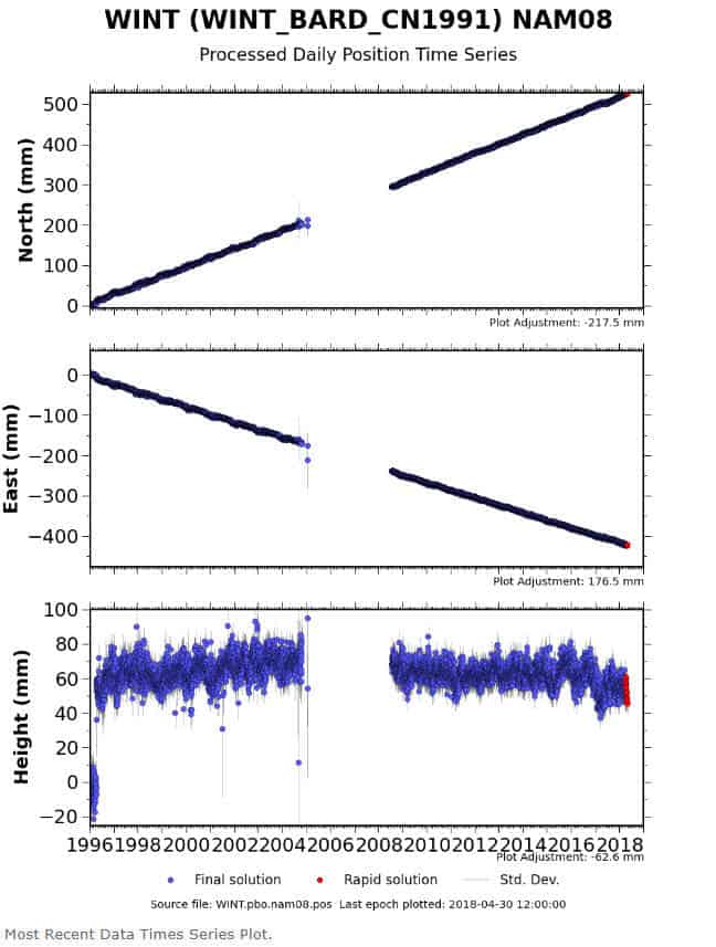
Here is a vertical time series plot of a CORS – P565, located in the southern end of the San Joaquin Valley near the town of Delano.
Wonder what the elevation will be after the next BIG earthquake and most of California slides off into the Pacific Ocean. ??? ??? ???

Years ago, I ended up doing verification on a 450-mile LiDAR project because for the railroad because one of their surveyors thought they found a 30+ foot bust in that area when they ran levels off of an NGS benchmark.
While doing some photo control work for several segments of high-speed rail in the Fresno area I could make out significant subsidence in the just the couple of years since the projects primary control was run.
At most I would say the OP photo was settlement and not subsidence. Subsidence is almost imperceivable at any given location, unless you are on fault line.
 Posted by: @holy-cow
Wonder what the elevation will be after the next BIG earthquake and most of California slides off into the Pacific Ocean. ??? ??? ???
Not sure, the San Andreas fault and most others in California are lateral faults aligned roughly north-south so the Southern Coast of California will not disappear into the Pacific Ocean, rather Los Angeles will eventually slide past San Francisco.

Might as well throw this in too…
Just got an official Tsunami warning by email a few minutes ago (first time that’s happened) saying be prepared to evacuate the marina if necessary. They did evacuate the Berkley Marina this morning. I think it’s an abundance of caution because the first surge has already passed; the latest tsunami coastal observations as of 11:15 a.m., San Diego had increased to 1.4 feet from 0.8 feet waves at 9 a.m.
The 2011 Fukushima (Thoku-ok earthquake) tsunami was a big deal in San Diego; docks were broken up, boats lost their moorings and minor shoreside damage. The bay’s shorelines became like 1-2knot rivers at times and surges came in for nearly 24 hours. Exciting times.
Here’s an interesting factoid: The safest place to be on a boat during a tsunami is not docked, moored or anchored in a bay, rather it’s at sea, in at least 300 feet deep water and more than a few miles from shore and harbor entrances. There you’ll never even notice a tsunami as they’ll only be a few inches high.
- Posted by: @john-putnam
At most I would say the OP photo was settlement and not subsidence. Subsidence is almost imperceivable at any given location, unless you are on fault line.
Fault lines have very little to do with subsidence. First, the geology has to be prone to collapsing, removing the natural voids in the soil as it “pancakes” when the aquifer below is drawn down. Drought certainly exacerbates it as more groundwater is extracted because of the limited allocations from the Feds and State of surface water via the conveyance systems, but the biggest factor is land use.
The El Nido Bowl that I mentioned previously was not drought induced. The land use had changed from grazing lands to water thirsty crops, and the underlying conditions were perfect for subsidence as the production ag wells sucked the groundwater out of the aquifer below. Thus a 2 foot plus drop in 24 months. It is nowhere near any known fault lines, nor is the location of the utility pole I posted previously.
The lateral, secular movement at the faults can induce some minor vertical displacement, but that is not really subsidence.
Here is a time series plot of a CORS in the East Bay area (Alameda) that is very close to the Hayward Fault. As you can see it is moving quite rapidly (5 cm/year +/-) to the northwest, but the vertical time series, albeit noisy, is essentially stable. The geological conditions are not conducive to subsidence, so despite the rapid lateral movement, it is not sinking.
While most people associate faults with horizonal movement such as the San Andreas, there are plenty of tectonic faults that have a strong vertical component. You can look at the CORS velocities in the Pacific NW, we are sitting on a subduction fault zone (yes, I know the stations are uplifting but the ocean plate is subsiding). Another striking example faults with a vertical component are the Steens Mountains in SE Oregon, one wrong step and you find yourself a couple of thousand feet lower.
I agree that subsidence in normally associated with underlying geology and not tectonic. The central valley is sinking in a large part by the extraction of water and petroleum. The point I was trying to make was that subsidence is not a localized and almost unperceivable unless there is something dramatic happening on a large scale. Vertical movement along a fault is not the normal case but would be noticed and still be subsidence vs settlement.
I agree that the Cascadia subduction zone dynamics are quite different than the lateral movement of the North American and Pacific Plates. The uplift there is not subsidence, as you know. If we get the “Big One” up there, most everything west of I-5 is toast. However, our subsidence can be very localized. This a 2′ plus drop in two years, very near the High Speed Rail alignment. If it ever gets built, I am not riding it.
Geologically local but if you looked at a topo map of a couple of couple of city blocks you would probably not see much difference. The only way to really see it is with GNSS observations or differential levels run from outside of the subduction area. That is what freak the BNSF out on the project I referenced. They ran from a benchmark, last measured in the 40’s or 50’s if recall correctly, near the right-of-way a saw the difference with GPS derived LiDAR data. Driving around the entire town you would never know the entire area had subsided so much. It is amazing what happens when you pump both the water table and oil dry.
As for the highspeed rail, it is going to be interesting to see how they adjust for the different rates of subsidence. The rail is laid out to the millimeter.
Ps if you are crab living on the western edge of Cascadia then you are subsiding.
GNSS observations on control in this area leaves you wondering. I can take this new R-10 and observe points from previous (1-2 y/o) jobs – tied with an R8-3 – within ~0.02′ vertically, but not so here. Really hoping to escape this LaBrea tar pit of jobs without contributing any error. Wish I could drag the whole board with me onto this job.
- Posted by: @john-putnam
As for the highspeed rail, it is going to be interesting to see how they adjust for the different rates of subsidence. The rail is laid out to the millimeter.
About 7 years ago I was asked to attend a HSR meeting to provide advice on how to deal with subsidence. My suggestion was to purchase a much wider RW footprint in those areas because they would need to deal with the ground not being where it was when the mapping and design were done, but the rail had to remain at the grade it was designed to. Oh, and to get out the checkbook for change orders during construction.


Log in to reply.